Socio-Ecological Setting
The many ways people interact with Heʻeia reflect the variety of ecosystems within the ahupuaʻa. Historically, a great number of families living in the ahupuaʻa skillfully managed the lands and ocean to sustain food resources. Fishponds lined the coast, an abundance of fish were present in Kāneʻohe Bay, and thriving loʻi kalo (wetland taro patches) produced taro. Konohiki (land managers) managed the sharing of resources among families. Ecosystem service assessments describe the supporting, provisioning, regulating, and cultural benefits that people derive from nature (Sterling et al. 2022). The Indigenous view, however, is that a reciprocal relationship exists between people and nature, often summed up in the phrase “if you take care of the land, the land will take care of you.” This section on the socio-ecological setting describes the some of the supporting, provisioning, and regulating ecosystem services that people have cultivated with the land and ocean areas of Heʻeia, and the cultural ecosystem services and significance that has grown out of this long standing relationship.
Chapter 3: Estuary Characterization
This section covers relevant research on the socio-ecological and environmental settings within Heʻeia.
You will find report summaries below as well as:
An interactive story map on the Environment Setting
A slideshow of wetland birds
I. Ecosystem Services: subsistence, commercial and recreational
The institution of private land ownership in 1848, known as the Great Māhele, was a pivotal point in Hawaiʻi’s history. Prior to the Māhele, private land ownership was a foreign concept and Hawaiʻi operated under a traditional form of land tenure. Aliʻi (chiefs) of a given region would assign konohiki (resource managers) to lead the daily resource stewardship of smaller land divisions carried out by the makaʻāinana (commoners). Of the many nested land divisions, moku (district or region) and ahupuaʻa (community-level land division) were important political boundaries and units of social-ecology. Through careful stewardship, kānaka ʻōiwi (native people) were able to achieve a state of biocultural resource abundance known as ʻāina momona. The Māhele caused drastic social, economic, political, and ecological changes.
By Matthew C.K. Kahoʻohanohano
About the Author:
Matthew C.K. Kahoʻohanohano is a kanaka ʻōiwi (Native Hawaiian) from Wailuku, Maui. He has been a graduate research assistant at the Heʻeia NERR since July 2020. Originally admitted into the Botany department at UH Mānoa as a masters student he recently transferred into the PhD program. His research interests are Hawaiian agroecology, biocultural restoration, and social-ecological systems theory.
During the Māhele, kānaka had to apply for the title of their land through the Land Commission. Land claims required a register document where claimants summarized the land and seascapes they were claiming under their kuleana (responsibility), or stewardship. Then a testimony of a neighbor or konohiki was submitted to verify the validity of the claim. Lastly, the claimed lands were surveyed to prescribe the property boundaries. If awarded, the claimant received a Land Commission Award (L.C.A. or L.C.Aw.) also known as a Māhele Award. These various documents contain a trove of valuable data about the Hawaiian social-ecological system during the mid-19th century, including the spatial distribution of inoa ʻāina (place names), kahuahale (house lots), and loʻi and other agroecosystems and habitat types and their associated species.
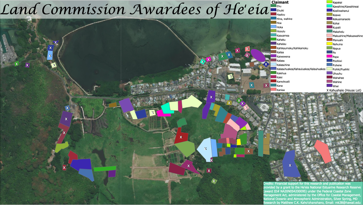
There were L.C.A.s throughout the Heʻeia ahupuaʻa. Within or near the current NERR boundary, there were a total of 42 awardees who claimed 102 ʻāpana (parcels) with a total of 65.14 acres.
This map depicts the two most common types of land-use, kahuahale (house lot) and loʻi (flooded taro cultivation). Often, though not always, houses and loʻi were co-located.This map informs contemporary restoration efforts by identifying areas historically appropriate for infrastructure and taro cultivation.
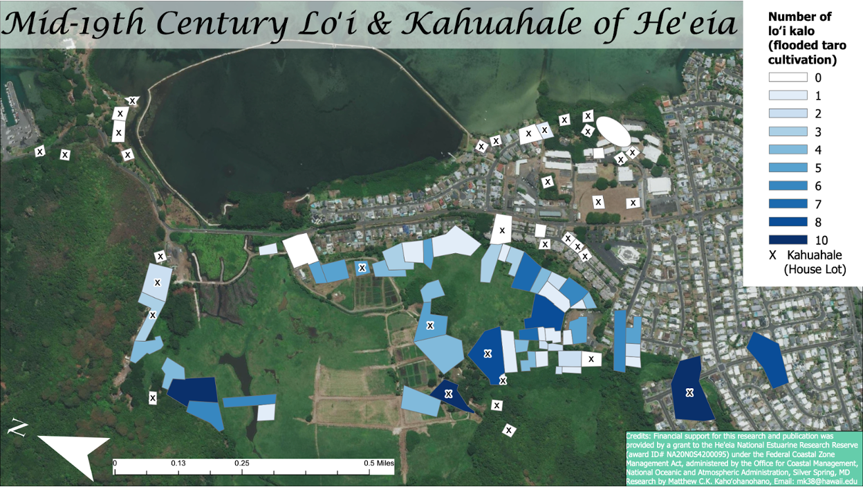
In addition to loʻi, other types of agroecosystems and associated crops and livestock were tended in Heʻeia. In this map, these are identified with labels. On the north side of the wetlands at the base of the foothills, there were a diversity of tree species along with maiʻa (banana), ʻohe (sugar cane), puaʻa (pigs), and ʻawa (kava). ʻAwa benefits from partial shade while puaʻa benefits from fallen fruit. It is also notable that among the fruit tree species were ʻalani (orange) and lemi (lemon). Other introduced crops on the Heʻeia landscape were ipuʻawaʻawa (bitter gourd) and ipuhaole (watermelon) planted near other vegetable type crops inland of the fishpond in a manner of cultivation called māla. Māla can be defined as non-flooded field cultivation, garden, or patch. A similarly translated term is a kīhāpai, but there are subtle differences between these systems and their function. A māla typically contains short-term food crops like perennials that are uprooted from the ground for harvesting (i.e. kalo, ʻuala, and ʻawa) and other annual vegetables. A kīhāpai implies the cultivation of longer-term crops, most likely tree species with utility that may include but is not limited to food. Lastly, the location of puaʻa (pig) production strongly correlated with the location of house sites, the majority of which were on the south side of the Heʻeia loko (fishpond).
Moʻolelo passed down over many generations speak to the abundance of fish in the area. One such moʻolelo tells the story of twins that were able to assume the form of the hilu fish (blackstripe coris). The female twin journeyed to Heʻeia in her fish form and created many other fish like herself along the way. The people of Heʻeia were excited to discover the new fish, and caught and cooked it in large numbers. When her brother went searching for his sister, he witnessed her being cooked, and he transformed into a strong wind which blew all the hilu back into the water. The story speaks to the importance of taking only what one needs. The hilu fish were known for being eaten raw, lawalu (steamed in leaves), salted, or broiled over a fire of coals by Hawaiians (Maly & Maly, 2003).
By Casey Ching
About the Author:
Casey Ching currently works as the Training and Engagement Program Coordinator for the He'eia NERR. She grew up in the Koʻolaupoko area and her graduate work included interviewing families in He'eia to determine the social and cultural benefits they gain from having access to ʻāina and its associated traditional practices.
Elders and long-time residents of Kāneʻohe Bay recall that catching and eating the nearshore fish species and invertebrates like crab, lobster, and heʻe (octopus) was an enjoyable pastime for the community and that fishing was a big part of their culture and way of life (Maly & Maly, 2003). The cultural significance of fishing is shown by the many fishing shrines within the Koʻolaupoko area built to demarcate boundaries and honor numerous fishing legends (Devaney et al., 1982; P. L. Jokiel, 1991).
Traditional fishing methods such as spearing, trapping, netting, and hook and line fishing were used to harvest from the nearshore waters of Heʻeia ( Jokiel, 1991). One such method is luelue net fishing, where lobster was used as bait within a round net of a finger width-sized mesh bordered by a walaheʻe stick. They typically lowered the net from a canoe and pulled it up once fish such as lauhau (butterflyfish) and panuhunuhu (parrotfish) were seen going into the net (Maly & Maly, 2003). Recollections of catching and eating lauhau fish at Moku o Loʻe using this method are noted in historical accounts from 1855 (Maly & Maly, 2003) . Other nets could be used to surround schools. Another method included feeding the fish a mix of seaweed and crushed kukui nut, a laxative, that allowed the fish to expel their food matter and make them hungry enough for fishers to easily bait them (Jokiel, 1991). Hawaiians also constructed fishponds along the shoreline by creating a wall of basalt and coral to enclose shallow waters. Mullet and milkfish were known for being raised in these ponds (Jokiel, 1991). At least 30 fishponds were previously built in Kāneʻohe Bay but only 12 fishponds remain (Devaney et al., 1982).
Subsistence fishing and the sharing that occurs between families in fishing communities continues to create close social networks and promote resilience (Vaughan & Vitousek, 2013) among local communities such as Heʻeia. While subsistence fishing is still practiced, commercial fishing in Kāneʻohe Bay has grown in importance over the last century. By 1892, the decline of Honolulu fisheries led to small-scale fishers from places such as Heʻeia supplying fish for the markets in town (e.g. Hall 1978).
Commercial, recreational, and subsistence fishers from other places on Oʻahu continue to spend time in the Heʻeia area today throwing and laying nets, casting lines from shore, harbor, or boat, or spearfishing at the many reefs.Fish commonly caught include trevally (jack) or pāpio (Caranx ignobilis), Hawaiian bonefish or ʻōʻio (Albula spp.), threadfin or moi (Polydactylus sexfilis) and Hawaiian striped mullet or ʻamaʻama (Mugil cephalus). Fishers using bamboo poles and line are a common sight along the Windward shore during summer runs of juvenile goatfish or oʻama (Mullidae) and bigeye scad or halalu (Selar crumenophthalmus) (Smith, 1993). In 2010, 158,991lbs. of fish were landed in Kāneʻohe Bay (DLNR‐DAR 2010).
In addition to fishers, the nearshore waters of Heʻeia support a wide variety of resource users. The Heʻeia Kea Small Boat Harbor provides easy access to Kāneʻohe Bay for Oʻahu locals and visitors and serves as a base of operations for several permitted commercial tour operations. In addition to Heʻeia Kea Small Boat Harbor, recreational boats launch into Heʻeia from the Kāneʻohe Marine Corps Base at Mōkapu. The State Department of Land and Natural Resources Division of Boating and Ocean Recreation established a State Ocean Recreation Management Area (ORMA) to be used for recreational and commercial purposes such as fishing, boating, thrill craft riding, skiing, diving, snorkeling, swimming, eco-tours, and research (Heʻeia NERR Management Plan, 2016). While recreational activities are allowed throughout Kāneʻohe Bay, commercial activities are confined to designated spaces. Commercial operations once dominated the bay. In 1992 the community created the Kāneʻohe Bay Master Plan to limit the scale and impact of commercial activity and reduce conflicts among different user groups.
II. Cultural Ecosystem Services
Cultural ecosystem services, or CES, is one of the four main categories of ecosystem services that describe the many benefits humans derive from nature. There is increasing interest in better understanding the human dimensions in resource management projects so that those involved - researchers, stewards, community stakeholders - can evaluate approaches to yield positive ecological, social, and other outcomes (Sterling et al. 2022). Efforts have been made to characterize CES as part of incorporating socio-cultural factors and reciprocal human-environmental interactions, and to re-define place-based, culturally grounded CES fitting to the place and people where the work is being conducted (Pascua et al., 2017). Within the NERR System, efforts have been made to take this Hawaiʻi-based CES model to define CES categories applicable to the NERRS (Sterling et al. 2022), and to incorporate into current activities in all sectors of the System. More information about these projects can be found here: CES in Estuary Stewardship and Management and Reciprocal Relationships in Reserves: Establishing a Community of Practitioners for Identifying and Using CES Approaches.
As an example in Heʻeia, Kākoʻo ʻŌiwi is restoring the wetlands in Heʻeia to increase the health of the ecosystem towards biodiversity of Native species and abundance of Native Hawaiian resources. As part of its restoration strategy, the organization established a program which allocates loʻi kalo (taro patches) to interested families to practice subsistence farming using Indigenous methods. Many cultural ecosystem services surfaced during interviews with participating families. They described a suite of community and cultural benefits stemming from the process of restoration, including enhanced social connections, cultural (re)connections to place, and physical and mental well-being, which inspired their sustained participation. Families valued the intangible benefits such as developing a reciprocal relationship between and among kānaka (Indigenous Hawaiians) and ‘āina (land). The agricultural practice promoted passing down of knowledge, passions, and environmental knowledge to new generations. Social connections (Pilina kānaka) motivated continual participation. Goods produced were perceived as shared benefits. They cherished the bond created through common experience with like-minded individuals, sharing of the work, and trusting relationships. They gained a sense of pride, accomplishment, and mental healing from having access to a safe space where they could practice their culture (Bremer et al., 2018).
III. Culturally Significant Sites
The mountainous section of the ahupua‘a is marked by the Ko‘olau cliffs, heiau, and caves. Pu‘u Keahiakahoe is the tallest pu‘u on the Ko‘olau overlooking the ahupua‘a of He‘eia and Kāne‘ohe. Along the cliffs lived the earth goddess, Kāmeha‘ikana, who lived in a cave named Kaualehu (the ash rain). The cave is believed to have once contained burials and is visible from the site of a former heiau called Kahekili (the thunder), of which a solitary stone remains today (Cruz and Hammatt 2012). The valley of Ha‘ikū at the base of the Ko‘olau mountains is an area rich in springs and streams, which allowed lo‘i kalo to flourish. The gods Kāne and Kanaloa obtained their drinking water from a spring called Kapuna, and the abundant fresh water irrigated the lo‘i kalo. At the bottom of the ‘Ioleka‘a pali is a pool associated with the legendary rat called ‘Ioleka‘a (rolling rat) (Cruz and Hammatt 2012).
The coastal waters of Kāne‘ohe Bay once contained at least thirty loko i‘a, including the He‘eia Fishpond. The kia‘i (protector) of the He‘eia Fishpond, Meheanu, lived on a small nearby section of the wetland called Luamo‘o and had the power to change herself into a mo‘o, a mythical lizard form, or a puhi ūhā, a conger eel that lives in brackish waters. Her presence in one form or the other was indicated by the color of the hau (hibiscus) thickets that grew around Luamoʻo. Another kiaʻi of Heʻeia fishpond was Lupe Kiaʻi Nui, a stingray who lived near Kēkepa island in the Kāneʻohe Bay and would patrol the wall of the bay to catch poachers.
Kealohi Point, which juts out from the shores below Puʻu Maʻelilʻeli and overlooks the mouth of Heʻeia Stream. Hawaiians regarded Kealohi (the shining) as a leina ‘uhane, a place where the souls of the dead leap into the sea. A sacred heiau (or Hawaiian temple) known as Kalaeulaula (the red point) was located on the peninsula. Only remnants of the heiau are visible since it was destroyed when a pineapple plantation was established on the site. The peninsula is now Heʻeia State Park, an 18.5 acre park that is owned by the State DLNR. The state park visitor center and dining hall were built atop the heiau complex. Currently, Heʻeia State Park is open to the public, and provides an important public access point to the estuary (Hawaii NERR Site Nomination Document, 2014).
Across Kāneʻohe Bay, a second peninsula frames the far end of the ahupuaʻa. The west side of the peninsula of Mōkapu (sacred island) belonged to the ahupua‘a of He‘eia and included fishing ko‘a (Cruz and Hammatt 2012).
The He‘eia NERR site has been subject to numerous archaeological and cultural resource studies (McAllister 1933, Yent and Griffin 1977, Kawachi 1990, Nagata 1992, Henry 1993, Freeman and Hammatt 2004, Carson 2006, Altizer 2011, Cruz and Hammatt 2012, Groza and Monahan 2012, Soltz et al. 2014). McAllister (1933) was the first to document the major sites around O‘ahu in 1933; with regard to He‘eia, he documented three cultural sites: He‘eia Fishpond, Kaualaukī Heiau, and the dwelling place of Meheanu at Luamoʻo. The He‘eia Fishpond was listed on the National Register of Historic Places (50-80-10-327) in 1973.
IV. Additional Resources
Hawaiian Studies 356, Aloha Kanaloa-Marine Resources and Abundance is an undergraduate course taught by Noelani Puniwai, Assistant Professor at UH Mānoa in the School of Hawaiian Knowledge, Center for Hawaiian Studies. In this course students are exposed to the resources and processes of the ocean, research, and management approaches, as well as a Hawaiian worldview of oceanic elements.
Click on the images below to see some of the work her students are doing right here in Kāneʻohe Bay.
Kanaloa O Kāneʻohe
By: Reina Setoguchi
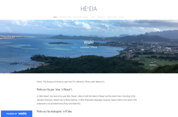
An Introduction to Kāneʻohe Bay
By: Briana Awa
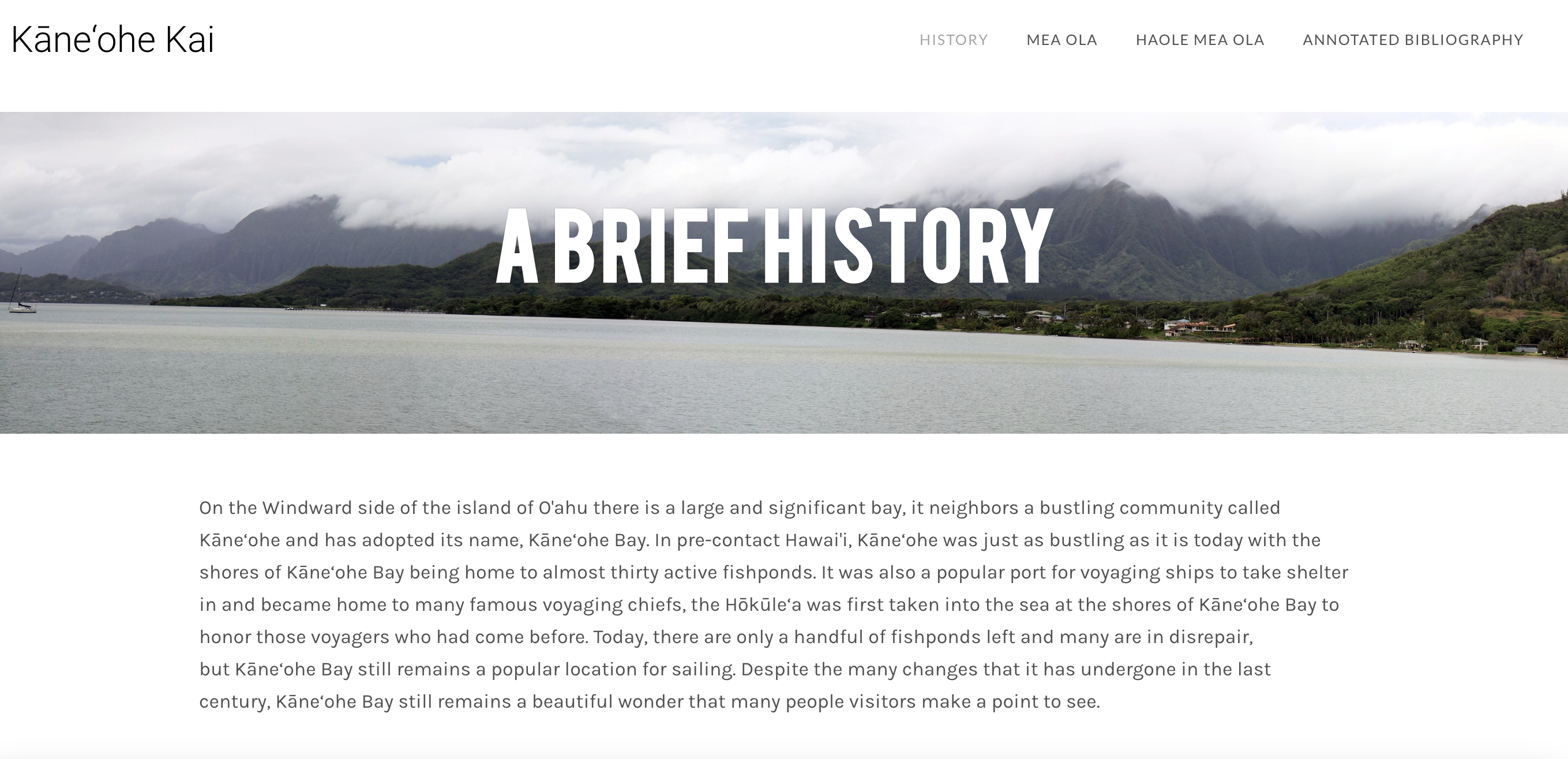
Kāneʻohe Kai
By: Nickolas Weatherwax
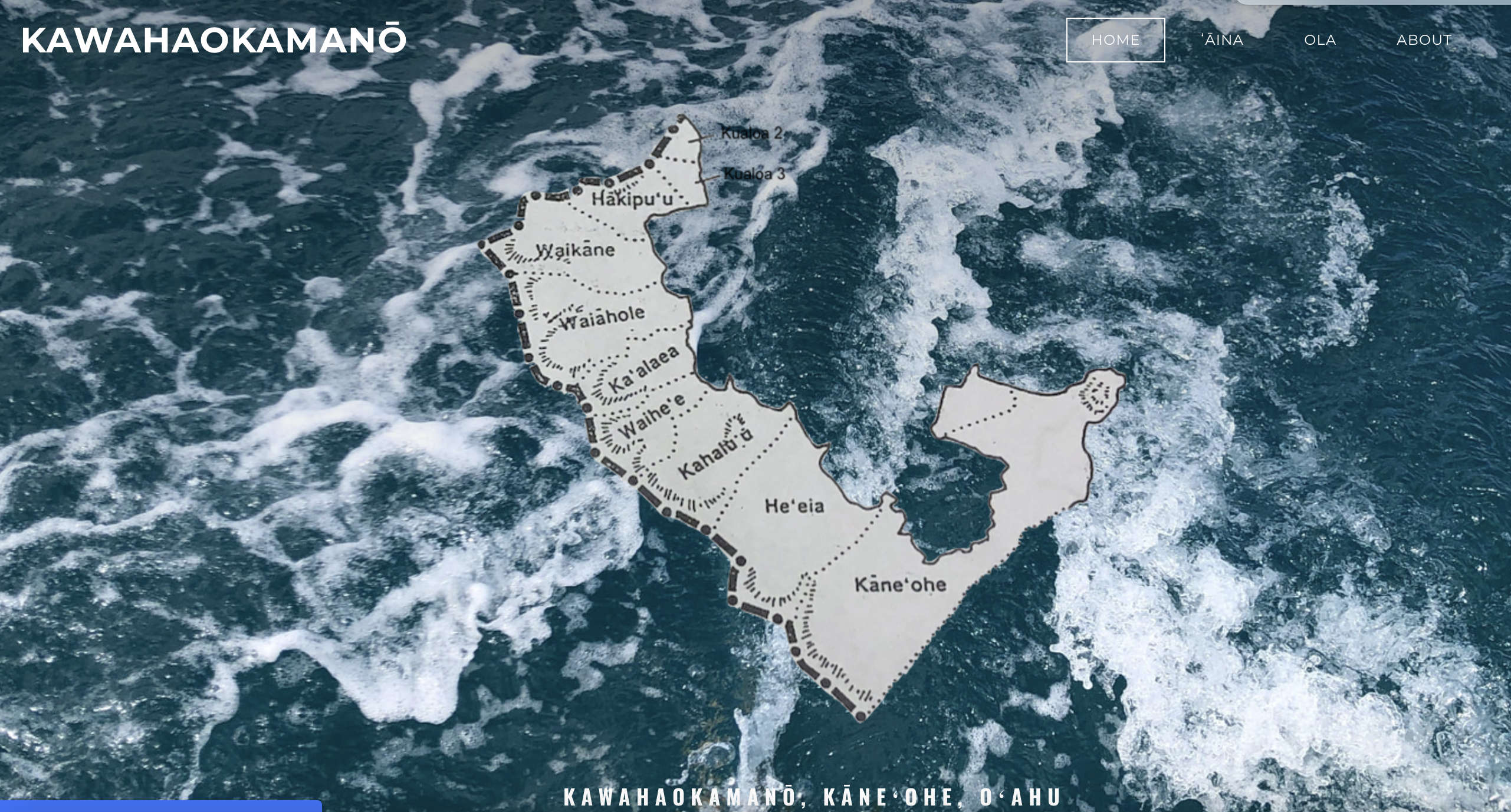
Kawahaokamanō, Kāneʻohe, Oʻahu
By: Kelsy Fujiyama
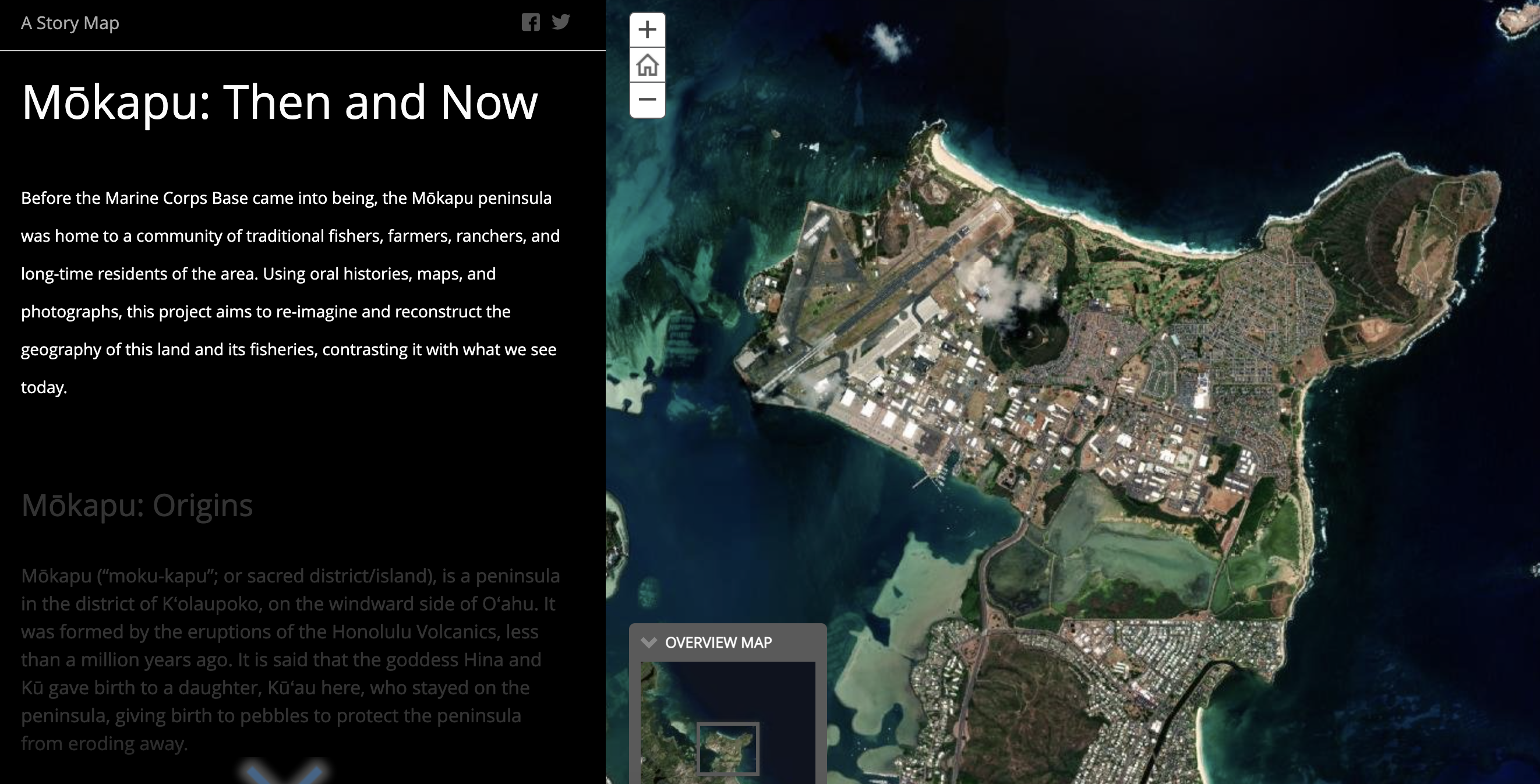
Mōkapu: Then and Now
By: Shreya Yadav
Mahina created this website in 2017 as a freshman in Kamehameha Schools' Hawaiian culture-based
cohort.
By: Mahina Kaomea
The following compilations provide some assistance in navigating and interpreting the multiple sources of historical and cultural information about Heʻeia.
- An extensively annotated list of place names and historical sources of information about the ahupuaʻa of Heʻeia HE WAHI MO‘OLELO NO HE‘EIA, MA KO‘OLAU POKO, O‘AHU SELECTED HISTORICAL ACCOUNTS OF HE‘EIA, AT KO‘OLAU POKO, O‘AHU (compiled by Kepä Maly1)
- An annotated list of place names within Heʻeia, part of “A Catalog of Hawaiian Place Names Compiled from the Records of the Boundary Commission and The Board of Commissioners to Quiet Land Titles Of the Kingdom of Hawaii” compiled and annotated by Lloyd J. Soehren (2010) and hosted on the Papakilo Database. Link
- A list of place names of Heʻeia with associated lexicology and moʻolelo, compiled by Donna Camvel and Kawaikapuokalani Hewett, kupaʻāina to Heʻeia. Report for Rob Toonen
- A historical and archaeological report on Mokapu Peninsula, commissioned by the Environmental Division of the Marine Corps Base Hawaiʻi. Mokapu:A Paradise on the Peninsula Stories From Not So Long Ago
- A version of the story of Keahiakahoe, compiled and translated by Pueo Paty, with revisions by Dr. Kawika Winter. He Moʻolelo no Keahiakahoe
- A 1915 retelling of a moʻolelo concerning the creation of humankind, touching upon places in Heʻeia. Legends of Old Honolulu - Creation of Man (pg. 70)
Environmental Setting
I. Origin and Evolution of the Estuary, Estuarine Geomorphology
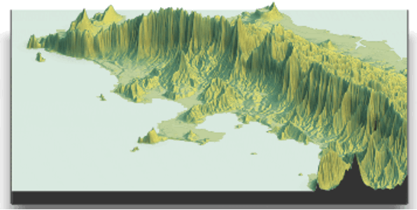
The island of Oʻahu formed from three shield volcanoes: Kaʻena, Waiʻanae, and Koʻolau (Sinton et al., 2014). The eastern three-fourths of the island today consist of the eroded remnants of the youngest of the three, the Koʻolau volcanic dome. Development of the physiographic features was controlled by geologic structure of the rift zone of the Koʻolau volcano, erosional processes, late volcanic activity, and changes in sea level (Takasaki et al., 1969).
The steep pali (cliffs) of the Koʻolaupoko moku were formed by a combination of volcanic activity, cataclysmic landslides, changes in sea-level, and wind and wave erosion (Takasaki et al., 1969) . Model created by Annie Innes-Gold and Sean Swift.
There are several genealogical chants that recount the formation of the islands. In one, the Kumulipo, the origin of the universe begins in Pō, which means darkness or chaos, or sometimes the deep sea. Another chant, called Palikū, meaning vertical precipice, alludes to a cataclysmic splitting of the mountains by an earthquake (Malo, 1898). Together, these various creation stories and other oral traditions convey the main geologic aspects of the formation of the land and seascapes of Hawaiʻi, including Heʻeia.
Volcanism and Avalanche
The Koʻolau Volcano erupted from a crater between Waimānalo and Kāneʻohe. Aʻa and pāhoehoe lava flowed downslope to the north, forming a basalt ridge that was about a mile taller than the current mountain range (Stearns, 1946)
Following formation of the giant ridge, a series of major avalanches from the Koʻolau Volcano took place between 2.2 and 2.9 million years ago (Garcia et al., 2006). One such event, the Nuʻuanu debris avalanche, carried debris 235 km out to sea and covered an area of 23,000 square km on the seafloor (Moore et al., 1989). The massive surge of rock created a tsunami 100 m high locally, depositing debris at high elevations on the other islands, and causing waves as high as 70 m to hit the coast of southern California (Satake et al., 2002). These avalanches, along with further weathering, created the steep cliffs and general shape of Kāneʻohe Bay.
In the earliest of times, moʻolelo recount, there was no sea, and no fresh water. The deity Pele brought the sea when she came to Hawaiʻi, so that she could use her canoes. She poured it from her head and great waves smote the land and covered the high ground except for the summits of Haleakala, Maunaloa, and Maunakea. Then it receded and lay calmly where it is today (Fornander, 1918).
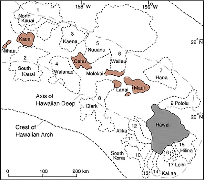
Figure. Map showing distribution of landslides throughout the Hawaiian Islands.https://hilo.hawaii.edu/~kenhon/GEOL205/Landslides2/default.html
Weathering
Weathering by rain and waves further eroded the ridges and flattened valley floors. Heʻeia means “washed.” A moʻolelo of the origin of the name says that the ancestors Haumea and Wākea were fighting a battle against a chief from Kona. During the battle, a huge wave washed ashore and dragged the armies out to sea. Wākea’s kahuna instructed him to cup his hands to make a heiau, and catch a humuhumunukunukuapuaʻa fish in place of a pig as an offering. Once the offering was made, the wave washed them back ashore on Kapapa islet. Haumea later adopted a young boy and named him Heʻeia after the event (Rose & Klieger, n.d.)
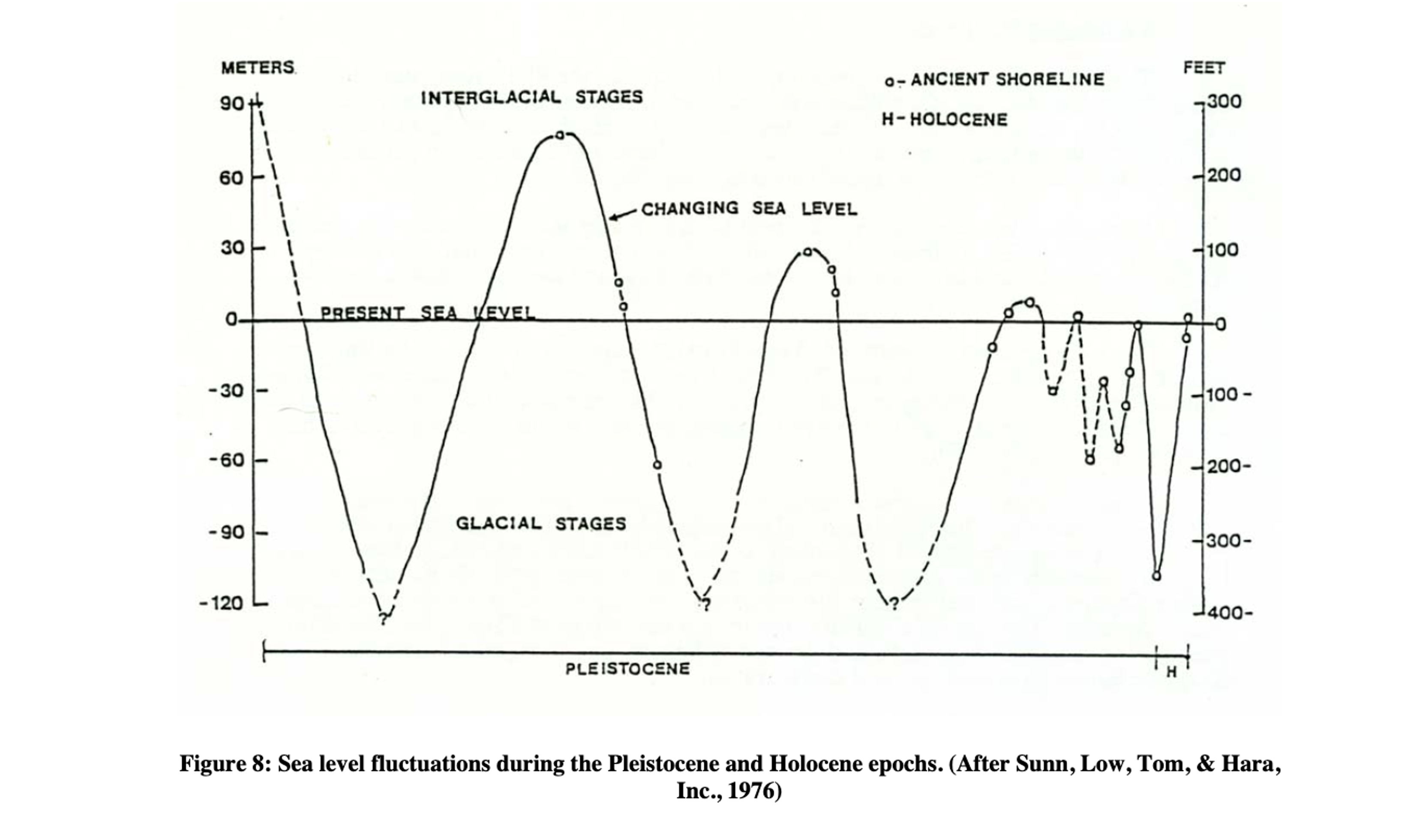
In the last two million years, according to Grigg (2012), “sea level fluctuated up and down about twenty times and by as much as four hundred feet… During the last ice age twenty-one thousand years ago, Kaneohe Bay was a dusty plain almost four hundred feet above the shoreline”. During times when the sea was higher, the submerged valley floors filled with sediment and became flat (Stearns, 1939).
In his Illustrated Scientific Guide to Kāneʻohe Bay, Oʻahu, Jokiel describes the weathering process:
In the million years since the Nu’uanu debris avalanche… erosion continued to shape the Kāneʻohe Bay watershed. The fluted columns of the Pali were formed by streams that cut into the vertical cliffs left along the Ko’olau volcano after the avalanche. Fed by rain from trade-wind clouds, the streams enlarged and their beds deepened the gullies, leaving high, sharp ridges between…. The original basalt ridges separating stream valleys became so eroded that currently only three reach the shore (Cox et al., 1973). These are: the ridges between Waiahole and Ka’alaea, between Kahalu’u and He’eia, and between He’eia and Kaneohe. The latter juts into the Bay as Pohakea headland and extends out to Moku o Loʻe (Coconut Island)
(P. L. Jokiel, 1991)
Thus, Heʻeia is the only ahupuaʻa within the Kāneʻohe Bay area with boundaries on both north (Māʻeliʻeli) and south sides (Pohakea) marked by ridges that reach the ocean.
A moʻolelo about Kaʻohelo, sister of the famous Pele and Hiʻiaka, recounts the formation of the ridge between Kahaluʻu and Heʻeia. Kaʻohelo traveled to Oʻahu and married the chief, Heʻeia. When she died, her body became the ʻohelo plant; the low ridge in Heʻeia now bears her name, Kaʻohelo.
Coral Deposits and Secondary Eruptions
Kaʻohelo’s had another sister whom she was close with, named Malulani. When Malulani died, her relatives brought her to Heʻeia, and made bundles of her body, which they scattered outside of Heʻeia. When the sea rose, the bundles became the sharp coral islets of Heʻeia, or Koʻa Mokumoku o Heʻeia. Thus, the hills on the land and in the ocean are sisters (Fornander, 1918).
The foundations of Kapapa and Kekepa islets are composed of eolianite rock: former dune sand deposited around 200,000 years ago by wind when the sea was more than 100 m lower than today (Fletcher et al., 2005; Stearns, 1970). The sea level subsequently rose, making the dunes into islets.
Evidence of a fairly recent “high stand” or sea level above current levels, comes from Kapapa islet, where the rocks and sand at the top of the island indicate that a beach formed there from about 5,000-2,000 years ago when the sea was 1.6 m higher (Fletcher & Jones, 1996).
The hills of Mokapu peninsula and Moku Manu, and others within Heʻeia were formed by secondary eruptions around a quarter of a million years ago, long after the Koʻolau Volcano was done. Sea levels were higher then, and the interaction between ocean and magma caused these further eruptions of tuff and cinder to break through the layer of coastal coral deposits (Stearns, 1939).
Bathymetry
Today, at 41.4 km2 (16 sq. mi.) Kāneʻohe Bay is the largest sheltered body of water in the Hawaiian Islands. It is about 12.7 km (7.9 mi) long and about 4.3 km (2.7 mi) wide (Holthus, 1986a).
The entire shoreline, except parts of Mokapu Peninsula, is ringed by shallow fringing reef .3-.9 m (1-3 ft) deep and extending 300-750 m (1000-2500 ft) out from shore (Cox et al., 1973). The bottom of the shoreline areas contains sand, fine silt, and clay, associated with stream deltas and dredge spoils (Roy 1970). Live coral grows further out at the edges of the fringing reef.
Beyond the fringing reef, the depth increases, ranging from 6-19 m (20-62 ft.), and the bottom is comprised of coral rubble, gray coral muds, and fine coral sands (Bathen 1968, Roy 1970). More than 70 patch reefs rise up from these depths and are exposed to the surface at extreme low tides.
II. Soils and Sedimentary Processes
There are six main soil series found in Heʻeia (out of 190 soil series found in Hawaiʻi), representing four of the twelve soil orders of the world (Hue et al., 2007; see also Web Soil Survey):
Ultisols
Four related Ultisols are found on the sloped areas of Heʻeia, including Moku o Loʻe, and are similar to other mountain soils on the Windward sides of the older Hawaiian islands, weathered by hundreds of thousands of years of rainfall. They are acid and infertile due to leaching of soluble minerals and, and are red or yellow in color from oxidation (ie. rusting) of iron and aluminum compounds. The iron oxide clay minerals form sand-like aggregate particles, making the soil well-drained and easy to dig or till. Despite being considered infertile from the perspective of Western commercial agriculture, these soils supported extensive agroforests in pre-contact times. After Western contact they were used for pasture and briefly in the 20th century they were heavily cultivated for pineapple and sugar production.
The Haiku series is named for Haʻikū, Maui, a mountainous area similar to the Haʻikū sub-valley in Heʻeia. Haʻikū means an abrupt break, such as a break in slope at the base of a steep mountain. The Lolekaʻa series was first cataloged near the boundary of Heʻeia and Kāneʻohe. The soil series name Lolekaʻa may be derived from a misreading of Iolekaʻa, the name of the nearby peak and sub-valley next to Haʻikū within Heʻeia. The Alaeloa and Waikane series were also first cataloged in nearby valleys by these names. Alaeloa references the Hawaiian term for red soil, ʻalaea.
Inceptisols
The Hanalei series was named for Hanalei, Kauaʻi, one of the important taro growing regions in the state. In Heʻeia, as in Hanalei, this soil forms in the valley bottoms and is ideal for loʻi. Silicate clay minerals (smectite) cause the soil to shrink and crack when dry, but swell when wet, creating a tightly sealed layer that holds water. In Heʻeia, as in other places, these fertile, alluvial soils are found throughout the wetland where the stream deposited sediment. It is dark gray to brown, with red and yellow mottles when dry.
Histosols
These marsh series soils are composed of a meter or more of mucky peat–organic matter that has accumulated from leaf litter and stream deposits. They are constantly flooded, leading to low oxygen levels which slows decomposition rates and causes organic matter to build up over time. Non-native introduced mangrove trees in Heʻeia stream mouth further added to the organic matter buildup.
Entisols
These Jaucas series soils are found on Mōkapu peninsula. They are almost entirely calcium carbonate sand, formed from coral, shells, and sedimentary rock composed of older deposits of these same materials.
Sedimentary processes
Sedimentary processes in Heʻeia have been examined since the early 2000s, specifically on impacts from the watershed into Kāneʻohe Bay (e.g., DeCarlo et al., 2007; Hoover and Mackenzie, 2009) as well as modeled impacts of nutrients and sediments through an integrated hydrological model (Ghazal et al., 2017; 2020).
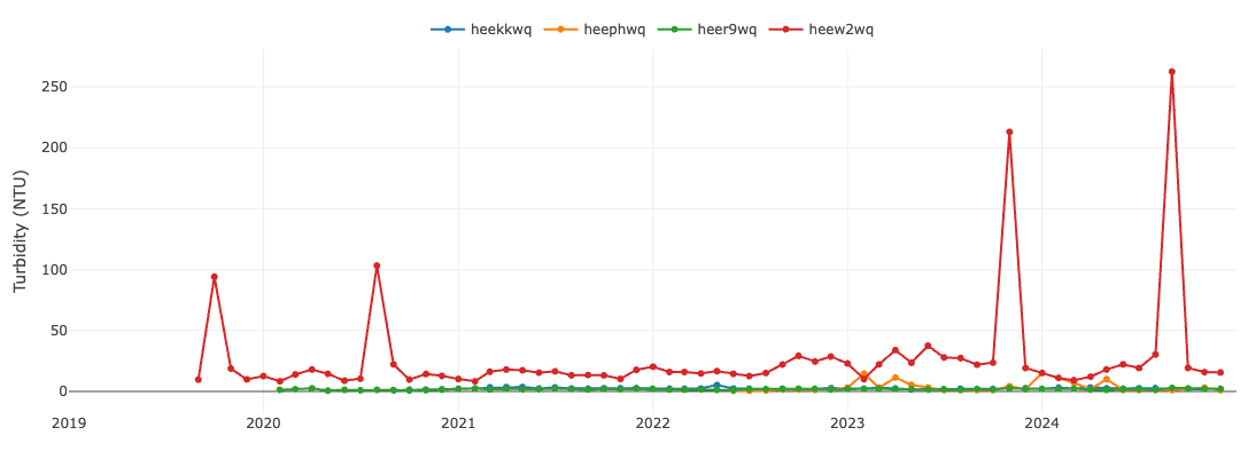
Since 2019, the Heʻeia NERR Research and Monitoring program has been monitoring turbidity and total suspended solids at 4 main water quality sites (see Chap. 4, Research and Monitoring for more info) as part of the System-Wide Monitoring Program, as well as 7 additional sites throughout the ahupuaʻa. As seen in the figure below, there are seasonal increases in sediment flux in the watershed (visible in stream site w2, shown in red below) associated with winter storms.
III. Climate and Weather
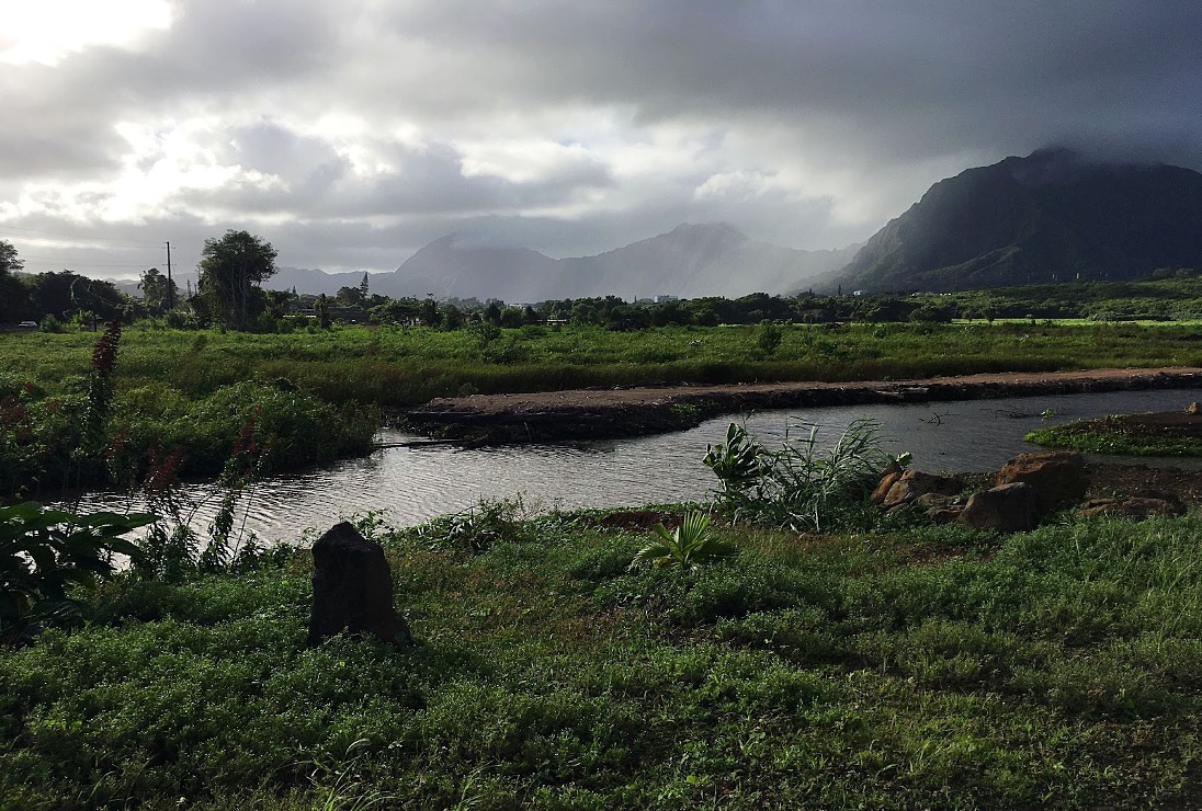
Photo of Koʻolau Mountains. PC: Melissa Mau
The Heʻeia NERR is located on the windward side of Oʻahu, which experiences cooler temperatures and higher rainfall than the leeward side of the island. The islands have steady trade winds which blow from the northeast a majority of the time at approximately 20 km per hour (10‐11 knots). These trade winds bring warm moist air to land. Hawaii has a semi tropical climate, with a rainy season lasting from October to May. Many high volume rain events happen during the rainy season.
The average rainfall in the Heʻeia watershed is 94 inches annually. The islands have steady trade winds which blow from the northeast a majority of the time at approximately 20 km per hour (10‐11 knots). The air temperature ranges from 20‐28 degrees C (68‐82 degrees F).
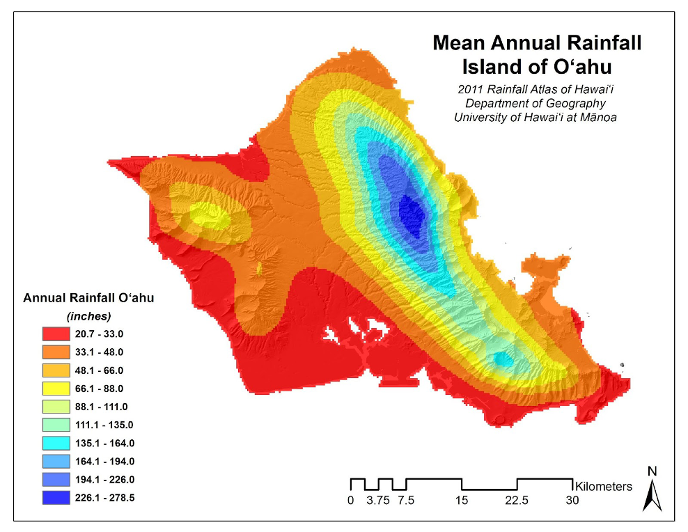
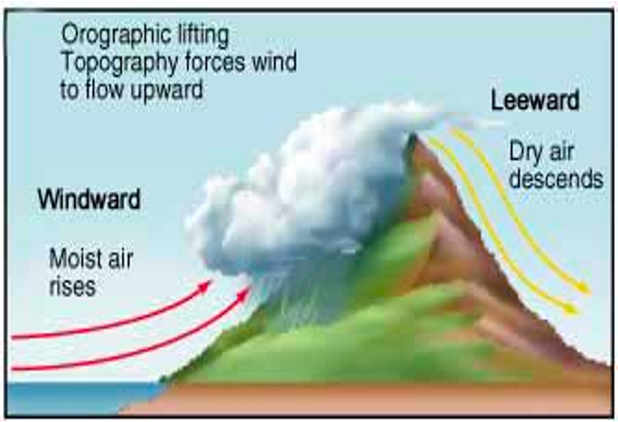
The Koolau mountains' steep cliffs force the trade winds and accompanying clouds upward, where they encounter a colder mass of air. This results in much higher amounts of rainfall in the upper mountains. This is called orographic lifting (Jokiel, n.d.). The upper mountain areas receive 15‐20 inches of rain per year while the coastal area receives only 3‐4 inches per year. Occasional heavy rain storms greatly increase the amount of rain received in Heʻeia watershed (Hawaii NERR Site Nomination Document). The Heʻeia watershed averages 94 inches annually, whereas the coastal areas receive moderate to frequent rainfall (Giambelluca, et al., 2013). Occasional heavy rain storms greatly increase the amount of rain received in Heʻeia watershed. The average annual air temperature ranges from 71 to 85°F, averaging 78°F (U.S. Climate Data 2015).

Our Hawaiian kūpuna (ancestors) were keen observers of their environment and the world around them. They were able to observe weather patterns and make predictions based on their intimate relationship with their surroundings. Our kūpuna were so attuned to the environment that they assigned individual names for the multitude of rains and winds throughout the Hawaiian Islands.
Here are a few Hawaiian resources that speak of the climate and weather in Heʻeia.
ʻĀpuakea: Rain name associated with Koʻolaupoko, Oʻahu, The ʻĀpuakea rain of Koʻolaupoko was named after ʻĀpuakeanui, the most beautiful woman in Kailua from the moʻolelo of the goddess Hiʻiakaikapoliopele
Ke ʻike aku i ke koʻa māʻokiʻoki o Heʻeia
Me ka ua ʻĀpuakea o Mololani
Ke hehi maila lā i Malaukaʻaē
Seeing the broken coral beds of Heʻeia
And the ʻĀpuakea rain of Mololani
Trampling on the Malaukaʻa
(Akana & Gonzalez, 2015, pg. 8)
Kālepa: Rain associated with Heʻeia
Ke nihi aʻela ka ua Kālepa
Ka ua ʻokiʻoki koʻa o Heʻeia
Ke hehi maila i ka maka o ke koʻa
A luhi ē — Luhi i ka ua ke koʻa
O Heʻeia Kea ē
The Kālepa rain moves quietly
The coral-breaking rain of Heʻeia
Trampling on the bud of the coral
Until weary — Weary from the rain is the coral
Of Heʻeia Kea
(Akana & Gonzalez, 2015, pg. 47)
Kanikoʻo: Rain associated with Heʻeia, Oʻahu, and with the Koʻolau wind. “Kani koʻo” refers to the tapping sound of the cane.
A kuʻu hoa e noho lā i ka laʻi
I walea i ka ua Kanikoʻo o Heʻeia
I ka ua Pōʻailauʻawa o Moelana
And my companion who resides in the calm
Relaxing in the Kanikoʻo rain of Heʻeia
In the Pōʻailauʻawa rain of Moelana
(Akana & Gonzalez, 2015, pg. 49)
Līpoa: Same as Uaakalipoa. Rain associated with Heʻeia, Oʻahu. Also the name of a seaweed.
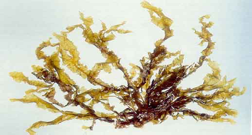
Photo of Limu lipoa (Dictyopteris plagiogramma). Credit: I.A. Abbott, An Ethnobotanical Study of Some Hawaiian Seaweeds, 1984)
Aloha nō ʻoe, e ka Mālualuakele
E ka makani anu o kuʻu ʻāina
He ʻāina, he hoa aloha no ka pali
He kāne hoʻi, he ipo no ka ua Līpoa
Beloved are you, O Mālualuakele
The cold wind of my homeland
A home, a friend for the cliffs
A mate, a sweetheart for the Līpoa rain
(Akana & Gonzalez, 2015, pg. 163)
Mololani: Similar to Lūlehua. Rain associated with Koʻolaupoko, Oʻahu. Also found in Panaʻewa, Hawaiʻi. Also the name of a wind and of a crater in Kāneʻohe, Oʻahu.
Kapu Nuʻuanu i ka ua Kiʻowao lā
ʻO ke alo hāliu i Heʻeia lā
Nānā i ka ua Mololani lā
Nuʻuanu in the Kiʻowao rain is sacred
Its front turned toward Heʻeia
Observing the Mololani rain
(Akana and Gonzalez, 2015, pg. 89 & 177)
One of the best known moʻolelo is the story of Hiʻiakaikapoliopele. During this epic journey, Hiʻiaka finds herself on the island of Oʻahu on the Pali- Koʻoalu, tormented by the Koʻolau weather.
Ino Koolau, e, ino Koolau!
Ai kena i ka ua o Koolau:
Ke ua mai la i Ma-elieli,
Ke hoowaʻawaʻa mai la i Heʻeia,
Ke kupá la ka ua i ke kai.
Haʻa hula leʻa ka ua
I Ahui-manu, ka ua hooni,
Hoonaue i ka puʻu koʻa,
Ka ua poai-hale1 o Kaha-luʻu.
Luʻu-luʻu e, luʻu-luʻu iho nei au
I ka puolo waimaka o ka onohi—
Ke kulu iho nei, e.
TRANSLATION
Vile, vile is this Koolau weather:
One soaks in the rain till heʻs full.
The rain, it pours at Ma-eli-eli;
It gutters the land at He-eia;
It lashes the sea with a whip.
The rain, it dances in glee
At Ahui-manu, moving
And piling the coral in heaps,
Shifting from side to side of the house,
This whisking rain of Kaha-luʻu.
Heavy and sad, alas, am I,
Mine eyes, a bundle of tears,
Are full to oʻerflowing.
(Emerson, 1915, pg. 90)
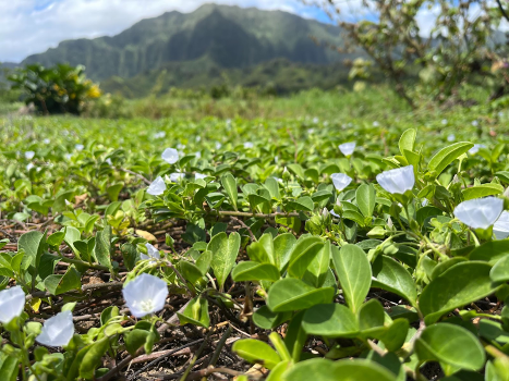
Pāʻū-o-Hiʻiaka is a perennial herbaceous non-climbing vine endemic to the main Hawaiian Islands. Paʻu o Hiʻiaka translates to the skirt of Hiʻiaka. Credit: Melissa Mau, 2022.
The Kanikoʻo rain is mentioned in the Legend of Halemano as Halemano reflects on the time when he and Kamalalawalu lived in the the forests of Moelana, in Kakele, Koʻolaupoko, Oʻahu.
Wela Koolau i na keiki uwe anu,
Kuu aloha kaikua e noho ai,
A kuu hoa e noho la i ka lai,
I walea i ka ua Kanikoo o Heʻeia,
I ka us poai lau awa o Moelana
Me he keiki makua ole la ka hine,
Ka hoolaau i kuu kino e,
Ka elele waha ole a ka manao.
Kuu wahine hoi, e hoi mai.
Translation
Koolau is made hot by the children who cry against the cold,
My native land, where the sea beats at the back
Of my companion who now dwells in the calm,
Enjoying the Kanikoo rain of Heʻeia,
That rain that makes the awa leaves of Moelana glitter
Like a fatherless child in its playfulness,
For it is affecting my body,
By its speechless messenger, love.
My love, O come, come back!
(Fornander, 1918, pg. 246)
IV. Hydrology and Oceanography (watershed and tidal conditions)
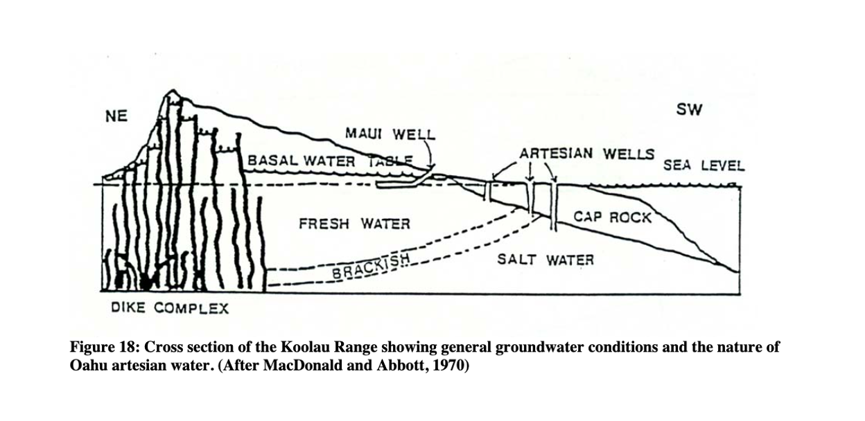
Hydrology
A foundational study was conducted by Izuka (1993) with US Geological Survey examining the geohydrology in Haʻikū valley in Heʻeia. Since then, Leta et al. (2016) and Ghazal et al. (2017; 2020) reported on results of the Soil and Water Assessment Tool (SWAT) models that assessed the impact of rainfall, temperature, and CO2 concentration changes on the water balance of hte watershed. These studies emphasized the need for more data as data scarcity was evident, and that future climate scenarios showed a reduction in groundwater flow components by as much as 15% due to predicted rainfall and temperature changes.
In 2024, USGS published an updated report, “Groundwater and surface-water interactions in the Heʻeia watershed, Oʻahu, Hawaiʻi: insights from analysis of historical data and numerical groundwater-model simulations.”
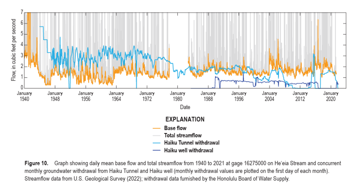
Currently, a study is underway (Wetland Water and ʻIke: Improving Understanding of Hydrology to Inform Management Decisions) to better understand stream and groundwater flow within the Heʻeia watershed, and to characterize the properties of water (nutrients, age, etc.) that may impact downstream processes such as primary productivity in Heʻeia Fishpond and nearshore waters.
Bathymetry
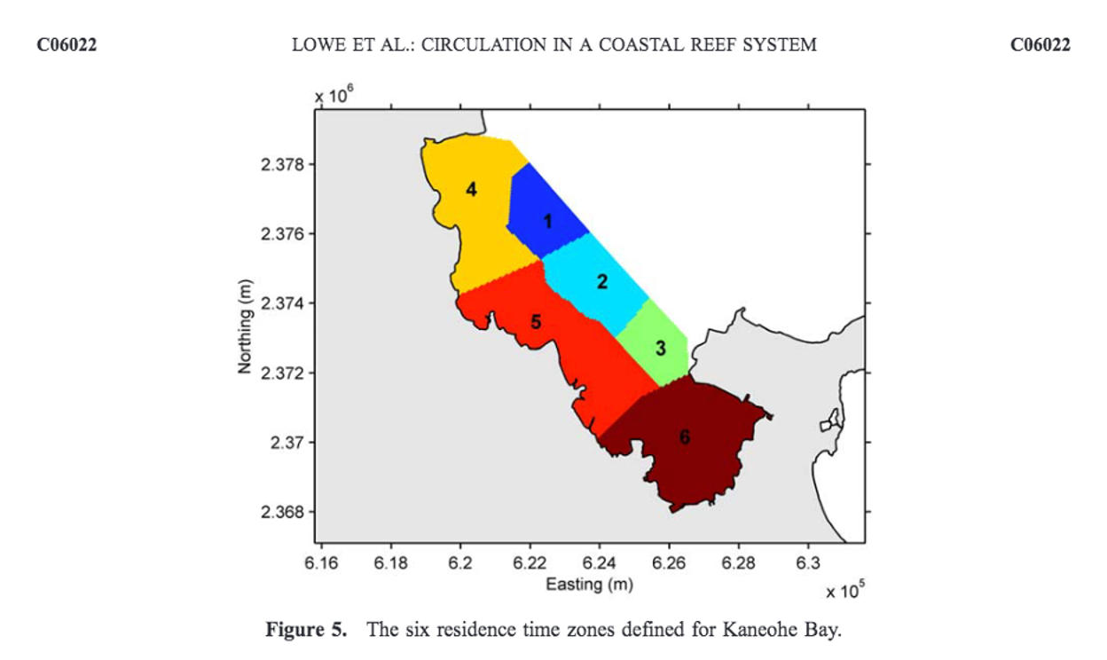
Bathymetry, winds, and tides control circulation patterns in Kāneʻohe Bay. Oceanic water flows into the Bay over the barrier reef with wave action as the primary driver (Bathen 1968). Water is transported out of the Bay through the Northwest and Sampan channels. Numerical experiments of Lagrangian particle tracking revealed high spatial heterogeneity in residence time within the Bay from less than 1 day to greater than 1 month (Lowe et al. 2009). Six residence time zones were defined, with the sheltered southern lagoon as very slow ~1-2 months (Lowe et al. 2009). The northern and central Bay, characterized by numerous patch reefs and a large barrier reef, had a relatively fast residence time on the order of hours or days (Lowe et al. 2009).
By Sarah J. Tucker
About the Author:
Sarah J. Tucker is a marine microbial ecologist earning a PhD in Dr. Michael Rappé's Laboratory at the Hawaiʻi Insitute of Marine Biology and at the Univeristy of Hawaiʻi at Mānoa. She co-leds the Kāneʻohe Bay Timeseries that uses monthly time-series sampling to examine surface marine microbial communities across coastal Kāneʻohe Bay and the adjacent offshore. She is a NOAA Margaret A. Davidson Fellow with the Heʻeia National Estuarine Research Reserve and has been working collaboratively with the Reserve and site-partner Paepae o Heʻeia to characterize the phytoplankton communities that support herbivorous fish productivity in the Heʻeia Fishpond.
Oceanography
For most of the year, the Bay is well mixed by tradewinds however, periods of high temperatures and low wind speeds can cause vertical stratification (Smith 1981). Freshwater entering the Bay from one of the eleven streams tends to mix into the entire water column during the winter, while in the summer it will remain at the surface (Jokiel 1991). The reduction of tradewinds and subsequent stratification of the water column within the estuarine Heʻeia Fishpond located in the southern part of Kāneʻohe Bay was associated with the onset of El Niño in Hawaiʻi, increased hypoxia, and fish mortality events at Heʻeia Fishpond (McCoy et al. 2017).
Intense rainfall events can also cause vertical stratification and freshwater plumes (Ringuet and Mackenzie 2005; Ostrander et al. 2007). Kāneʻohe Stream in the southwestern corner of the Bay accounts for the largest source of freshwater and many freshwater plumes have been observed in this area of the Bay (Ostrander et al. 2007; Drupp et al. 2011). The extent and duration of freshwater plumes are influenced by wind forcing and surface currents, as well as the intensity of precipitation (Ostrander et al. 2007). Nutrient loading from rainfall and terrestrial runoff produce a rapid change in nitrogen:phosphorous ratios which typically drove the bay waters towards phosphorous limitation (Ringuet and Mackenzie 2005).
Almost a third of the southern sector of Kāneʻohe Bay can cover be covered by nutrient-enriched freshwater during storm events, rapidly changing the relatively oligotrophic, nitrogen-limited southern sector, and subsequently triggering phytoplankton growth (Laws and Allen 1996; Ringuet and Mackenzie 2005; Hoover et al. 2006; Cox et al. 2006; Ostrander et al. 2007; Drupp et al. 2011) An increase in abundance of microphytoplankton and phytoplankton biomass generally showed a 3 to 6 day lag following the increase in nutrient input (Cox et al. 2006). Phytoplankton growth corresponds to rapid declines of nitrogen levels and enhanced phytoplankton biomass typically persists in the Bay across timescales of a few days to weeks depending on conditions and location relative to the runoff (Jokiel 1991). With less influence from streams and rivers, the physical and biogeochemical properties of the northern and central areas of the Bay are more similar to those of the oligotrophic, open-ocean waters surrounding the Hawaiian Islands (Smith 1981).
V. Water Quality
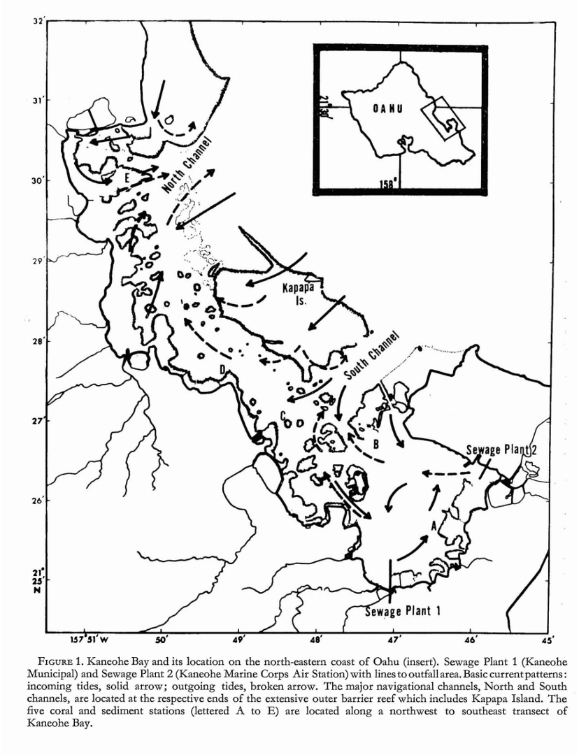
Kāneʻohe Bay has endured a number of human-induced events severely impacting water quality. These studies are outlined in a number of studies throughout the years (e.g., Laws and Redalje, 1979; Jokiel et al., 1991). For example, these included a discharge of untreated sewage into the southeastern portion of the Bay from 1951 to 1972, causing eutrophication, decreasing biodiversity, and altered ecosystem structure. Coral reefs were displaced by green bubble algae. Despite its “unnatural history”, Kāneʻohe Bay has demonstrated resilience as outlined in Bahr et al. (2015).
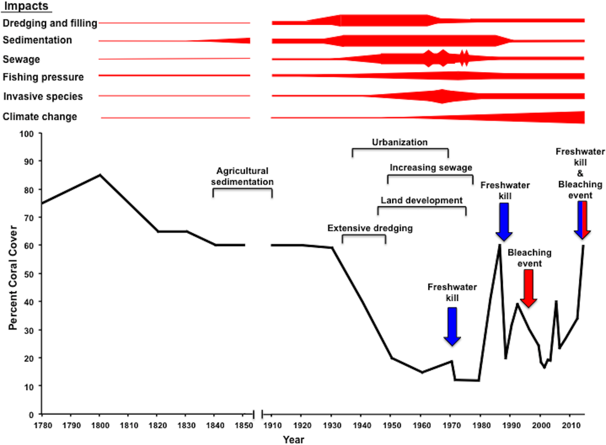
Figure from Bahr et al. 2015 showing reef response to major impacts during Western Era.
The water bodies in the He‘eia NERR consist of the perennial He‘eia Stream, the estuary, He‘eia Fishpond, and the semi enclosed Kāne‘ohe Bay. Water quality in these water bodies is important, because it affects the health of fish and coral populations in the bay, the quality of drinking water on land, and the resilience of natural water systems in the face of climate change.
Observed water quality impairment in the Heʻeia NERR likely originates in the uplands. Runoff from uplands may include sediments naturally eroding from forest lands; nitrates from fertilizer runoff, septic tanks, sewage, or erosion of natural deposits; and pollutants from urban development and road construction (Sumiye 2002). Nutrient and sediment-rich fresh water runs off into Kāne‘ohe Bay, especially during storm events, which induces phytoplankton blooms and threatens the health of the coral reefs in the bay (DeCarlo et al. 2007, Drupp et al. 2011, Guidry et al. 2013).
State of Hawaiʻi Department of Health (HIDOH) is required by Clean Water Act Section 303(d) to report on the state’s water quality on a 2-year cycle, and to submit a list of waterbodies that do not meet state water quality standards, plus a priority ranking of listed waters for total maximum daily load (TMDL) development, based on the severity of pollution and the uses of the waters (HIDOH 2018). Both He‘eia Stream and Kāne‘ohe Bay were on the list for nonattainment of one or more of the water quality standards, so their status is reported on a 2-year cycle (HIDOH 2018). In 2014, He‘eia Stream did not meet the standards for nitrate+nitrite (NO₃+NO₂) and total phosphorus (TP) during both the wet and dry seasons, but had attained the standard for turbidity, total suspended solids (TSS), and total nitrogen (TN) (HIDOH 2018). Kāne‘ohe Bay (Central Region, in the He‘eia NERR) had not met the standards for TN, NO₃+NO₂, ammonium (NH4+), and turbidity, but there was insufficient data to evaluate bacteria, TP, and chlorophyll-a (chl-a) (HIDOH 2014). Most recently, the 2018 HIDOH Water Quality Monitoring and Assessment Report reports that Heʻeia Stream currently attains all wet season water quality standards resulting in a delisting of NO₃+NO₂, while it is still listed for total nitrogen and NO₃+NO₂ only during the dry season. Kāne‘ohe Bay (Central Region, in the He‘eia NERR) is listed for total nitrogen, NO₃+NO₂, NH4+, and turbidity for the wet season.
Since 2012, He‘eia has been a priority watershed under HIDOH’s Clean Water Branch Polluted Runoff Control Program (PRCP). The PRCP has funded projects in He‘eia under the Clean Water Act Section 319 that aim to reduce sediment and nutrients in the watershed. Two water quality monitoring projects in He‘eia Stream were conducted until 2022 through DOH and other partners such as Hawaiʻi Sea Grant, Paepae o Heʻeia, Kākoʻo ʻŌiwi, and The Nature Conservancy (Hawaiʻi Nonpoint Source Management Plan 2021-2025). From 2019, continuous water quality monitoring projects are now conducted through the Heʻeia NERR System-Wide Monitoring Program in Heʻeia Stream and adjacent waters (see Research and Monitoring section 4 for more info, and see a recent poster on this work
).Biological Communities
I. Biotic Habitats: Influence of physical environment on the biota
Forest/agroforest
The upland areas of the He‘eia marshland are currently overgrown with nonnative invasive species. Restoration of the upland areas will include the implementation of a hybrid ecosystem framework where there is a strong emphasis on enhancing the ecological characteristics of the area and improving ecosystem functionality. Using a hybrid ecosystem framework, restoration of the upland areas will include removal of invasive non-native plant species, but allow for select non- native plants to remain, particularly those species that provide key forest structural attributes or important ecosystem services. A study is currently underway utilizing agroforestry restoration scenarios, as informed by Native Hawaiian resource management strategies and historical ecology, to inform current restoration strategies.
As the upland areas are to be restored with mainly native tree species, this may contribute to supporting a more resilient habitat for native and endemic fauna and flora. Given the potential for increased intensity and frequency of storms under climate change scenarios, a predominantly native forest is expected to capture rain and decrease the runoff that now occurs in the area that is overgrown with invasive grasses and other invasive species. Kāko‘o ‘Ōiwi is the main site partner for restoring the upland areas within the He‘eia NERR, and plans are in place to implement an effective monitoring strategy to understand and assess the effects of the restoration on specific ecosystem services. In addition to developing a monitoring strategy for the upland forest, the He‘eia NERR will also provide technical assistance, help to establish baseline conditions, and offer planning functions to support these restoration activities being implemented by Kāko‘o ‘Ōiwi.
The freshwater forested/shrub type wetland occurs in a narrow belt around the upland habitat in the southern part of the He‘eia CDD. This forested/shrub type wetland comprises trees like java plum (Syzygium cumini) and shrub species such as cat’s claw (Caesalpinia decapetala), Cuba jute (Sida rhombifolia), koa haole (Leucaena leucocephala), and guava (Psidium guajava). At the southern boundary of the He‘eia NERR, where He‘eia Stream enters the He‘eia CDD, this wetland type supports a thick forest of hau trees (Townscape 2011a and b).
Wetland (loʻi and wetland)
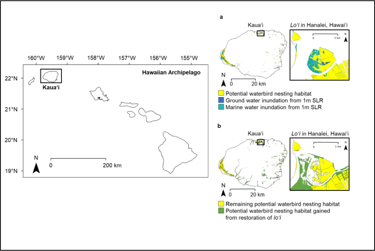
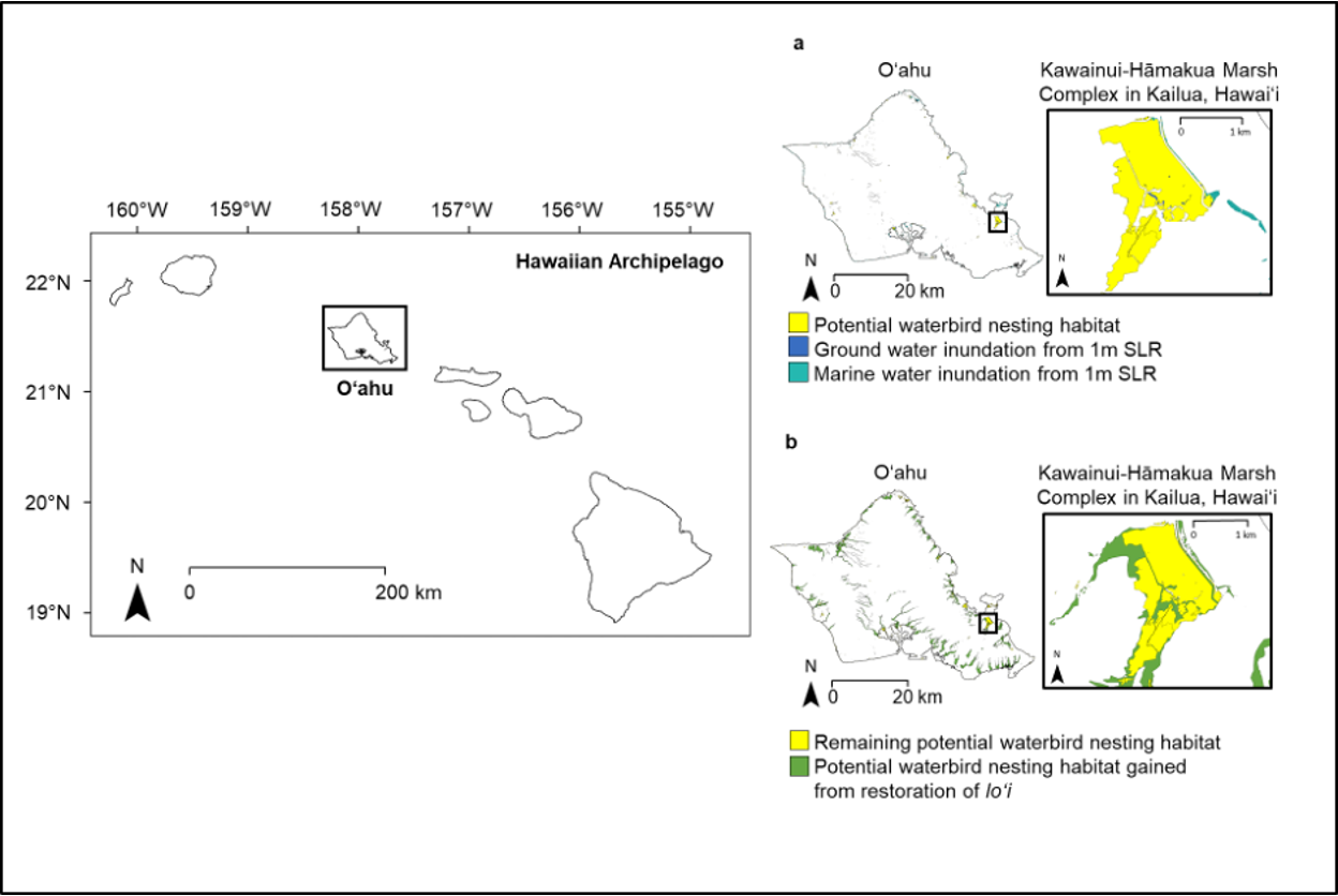
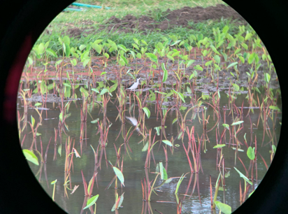
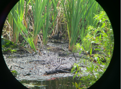
The Heʻeia wetland (an area locally referred to as “Hoi”) is a critical component of the Heʻeia watershed system embedded within the 2,248 acre Heʻeia ahupuaʻa. In traditional times, Heʻeia represented one of the most extensive areas of wetland taro cultivation of Oʻahu. Until the mid‐1930s, the Heʻeia wetlands were a thriving agricultural landscape, producing volumes of kalo, a nutrient dense dietary staple for Hawaiians, and creating opportunities for social and economic advancement for the families of Heʻeia and Kāneʻohe. Hoi once supported nearly 300 acres of kalo wai (wetland kalo) cultivation and contained at least three commercial processing facilities (poi mills). The active, ongoing cultivation of kalo at Hoi also served a critical role in the hydrology of the Heeia watershed, mitigating the effects of terrestrial runoff on adjacent estuarine and inshore coral reef ecosystems of Kāneʻohe Bay (Heʻeia Site Proposal 2013).
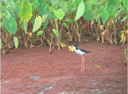
In the decades since the 1930s, extensive real estate development in surrounding areas and the decline of commercial kalo production in the Heʻeia wetlands resulted in the loss of the once thriving kalo fields of Hoi. The decline of wetland kalo production at Hoi and elsewhere in Hawaiʻi has had significant ecological impacts on wetland, estuarine and inshore marine ecosystems and far‐reaching social, cultural, and economic implications for Hawaiians. Kākoʻo ʻŌiwi’s establishment in 2006 to implement Mahuahua Ai o Hoi (“Replanting the Fruit of Hoi”) on 405 acres of the He’eia wetlands actualizes a community-driven vision to restore the loi kalo systems at Hoi. Strategies include restoring the natural hydrodynamic regimes and other ecological functions of the Heʻeia wetlands. Of the 405 acres under restoration, 202 acres are projected for wetland restoration. Since Heʻeia marsh is one of the few remaining shorebird habitats on Oahu, the restoration of the wetlands is critical for these birds. The U.S. Shorebird Restoration Conservation Plan lists Heeia Marsh as a degraded site in need of restoration (Engilis, Jr., A. and Naughton, M. 2004)
Stream
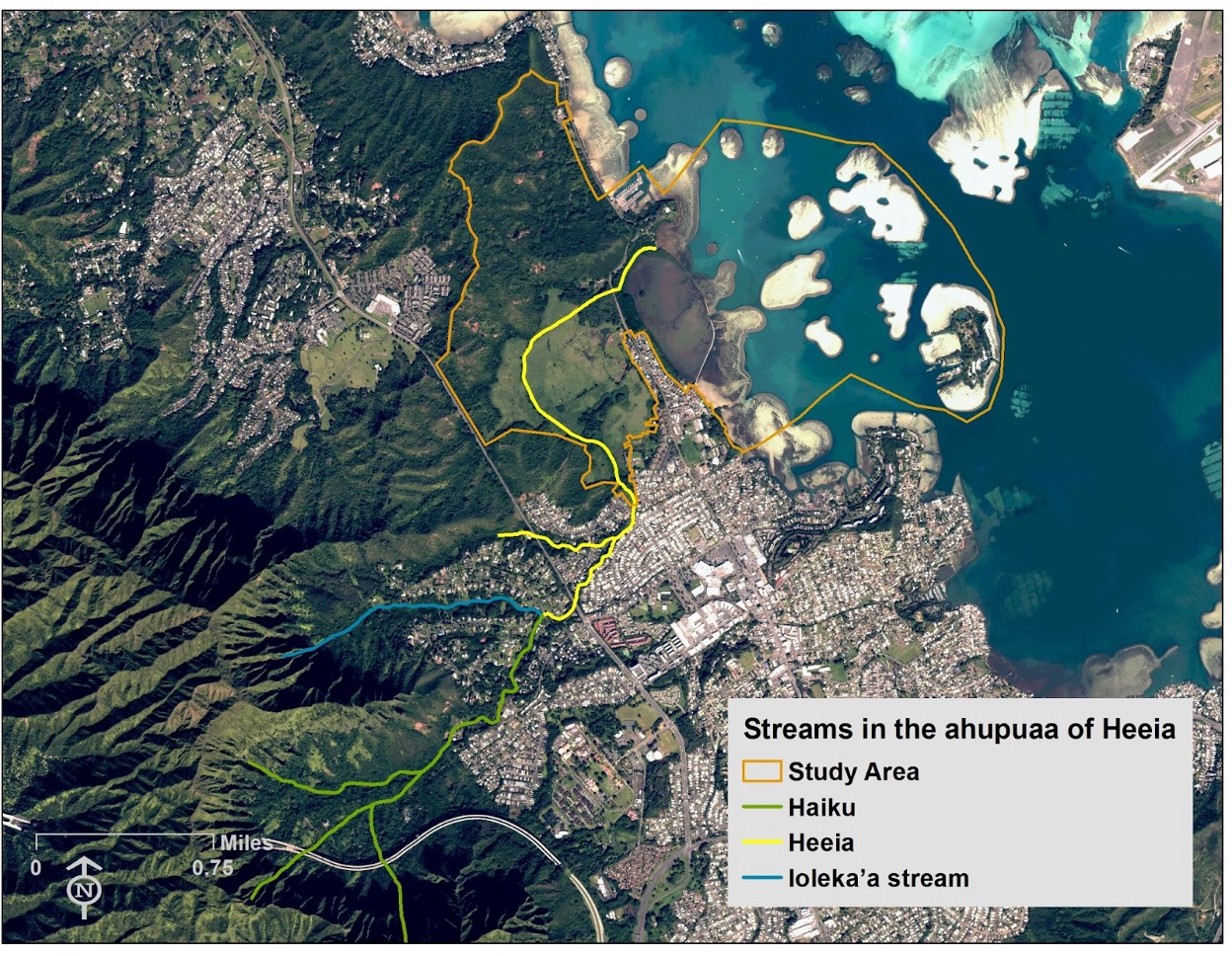
The He‘eia watershed totals 3.5 square miles (2,240 acres) (Parham et al. 2008) and extends beyond the boundaries of the He‘eia NERR, up the Ha‘ikū and He‘eia valleys, to the peak of the Ko‘olau Mountains. Ha‘ikū and ‘Ioleka‘a Streams merge to form the perennial He‘eia Stream, which runs through the He‘eia NERR. This watershed includes lands that are zoned for urban, agricultural, and conservation uses.
One of the unique attributes of the He‘eia NERR is that the watershed and ahupua‘a are close and accessible to the community and researchers. The total length of He‘eia Stream from the top of the forested upper reaches of the watershed to the end of the stream mouth as it enters Kāne‘ohe Bay is only 7.1 miles (Parham et al. 2008). One can stand at the mouth of the stream and look up to see the origins of the stream and watershed at the top of the Ko‘olau Mountains.
Heʻeia Stream, which runs through the site and discharges into the bay, is a perennial stream formed from two upland streams, Haʻiku and ʻIolekaʻa. The area that these streams drain is approximately 4 square miles. The low‐lying wetland areas are susceptible to flooding, and lie within Federal Emergency Management Agency’s AE flood zone. This zone is susceptible to flooding at the 1 percent annual flood event level. Erosion is a concern during peak discharge events (estimated to be 9,500 cubic feet per second (cfs)).
A current study examining surface stream and groundwater in the Heʻeia wetland and nearshore waters has potentially revealed through Hydrogen and Oxygen isotopes and analyses of radon the approximate proportion of groundwater in surface streams through the watershed. This study has preliminary results that indicate that the groundwater and surface streams in the Heʻeia wetland may be more influenced by lateral flow across the ahupuaʻa in Koʻolaupoko, and not necessarily by the water stored and found within the dikes in the Heʻeia ahupuaʻa.
Coral Reef Ecosystem: fringing, patch, barrier
There are three types of reefs in Kāneʻohe Bay: fringing reefs, patch reefs, and the barrier reef. Fringing reefs are shallow quiet-water reefs that occur along most of Kāneʻohe Bay's land perimeter and average less than 1 m (3.3 ft) in depth. Fringing reefs generally extend outward for 300-750 m (1000-2500 ft) (AECOS, 1981). Those in the NW sector of the bay are slightly wider and deeper. Natural breaks in the fringing reefs occur where freshwater streams have cut and maintain channels. Some areas of the reef flat have also been dredged for boat channels. This is especially true in the SE bay. Fringing reefs along the south basin were extensively dredged and filled for seaplane runways in the late 1930's and World War II era.
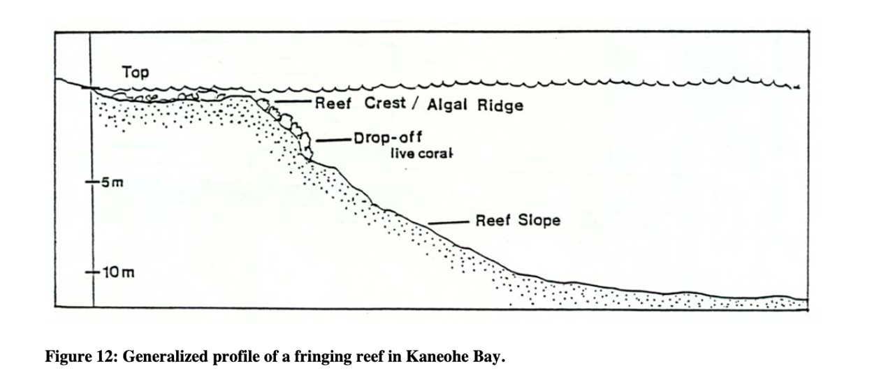
Fine, land-derived sediments occur prominently along the shoreline and grade into marine sediments toward the seaward edge on shallow surface portions of the reef known as the reef flat (Figure 12). Reef flats are exposed to extremes of environmental conditions such as changes in salinity, freshwater runoff, periodic exposure to air, and sedimentation. These environmental conditions result in limited coral development. Fringing reef flats in much of the bay, however, do have high standing crops of fleshy algae (Smith et al., 1981).
At the seaward end of the reef flat is a hard-bottomed wave-resistant algal ridge or reef crest. This crest is the highest part of the reef. It is often exposed during low tides.
Beyond the crest a near vertical coral covered drop-off extends about a meter ( 3.3 ft) down to the reef slope, which continues to the lagoon floor. Coral cover as well as abundance and diversity of reef fish tend to be high on the reef slope. Fine muddy sediments surround the corals. Although sediments below the actively growing coral generally get finer with depth, large blocks of slumped off coral rock frequently occur in the upper sections of the slope.
Live coral coverage on the fringing reef varies according to environmental conditions. In the NW portion, where water circulation and mixing are good, corals are abundant and occur at greatest depths. In the SE portion, where urbanization, runoff, and sedimentation is greatest and circulation is sluggish, coral development is poor. The SE bay may have had some of Hawaii's finest coral gardens at one time (Banner, 1974; Devaney et al., 1976).
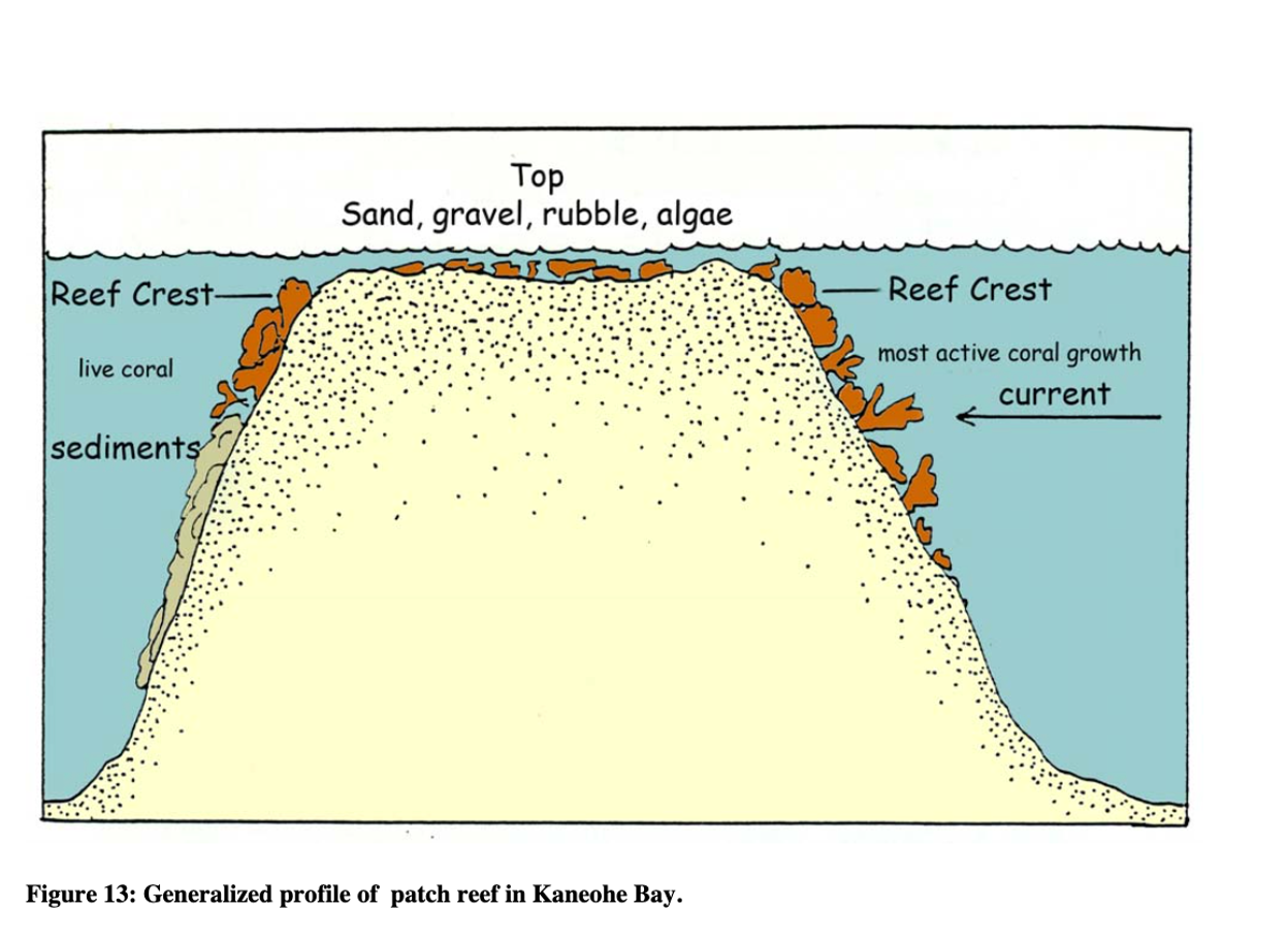
Ahu a Laka, named as an altar for the goddess of hula, is a sandbar and barrier reef with a depth of 0.3-1.2 m (1-4 ft) that spans the mouth of the bay, comprising a third of the total area. It consists almost entirely of extensive shallow coral (live and rubble) and sand.
The barrier reef protects the inner bay from ocean and storm swells. In addition, the southeast portion of the bay containing Heʻeia is further protected and semi-enclosed by Mokapu Peninsula and Moku o Loe. This portion of the bay is named Ke Kai o Malulani, or the sea of heavenly peace, alluding to Pele’s sister Malulani, whose body forms the islets of the bay.
Two natural navigable channels 6 km (3.8 mi) apart (Cox et al., 1973) cross the barrier reef and lead straight into the Bay. The northwest “Mokoliʻi” channel has been dredged to a depth of about 10 m (33 ft) to accommodate larger ships. Large amounts of coarse sand are actively being transported by currents into the Mokoliʻi channel. The southeast “Sampan” channel has not been dredged and has a depth of about 2 m (6.6 ft). Larger coral rubble predominates in this channel. A small channel was dredged adjacent to the Mokapu Peninsula and feeds into the Sampan Channel. Another channel dredged to a minimum of 12 m (40 ft) runs the entire length of the bay.
II. Microbiological and Plankton Components

Microbiological Components
As Hawaiian watersheds are highly interconnected, loko iʻa provide snapshots of ecosystem health for the entire ahupuaʻa. Fecal contamination was examined in Moehlenkamp et al. (2018), confirming the presence of 3 specific bacterial groups in Heʻeia Fishpond: Enterococcus and Bacteroidales, and C. marimammalium, an indicator for contamination from avian sources. In this study, the avian source was identified to be from the cattle egret colony on an island full of mangrove in the northwest end of the Fishpond, which has since been removed.
There are several graduate theses at University of Hawaiʻi at Mānoa that examined planktonic diversity (bacterial and eukaryotic) in Heʻeia (see Research and Monitoring section Chapter 4 for more info on past and ongoing projects).
Plankton of Kāneʻohe Bay and Surrounding Waters
In otherwise oligotrophic tropical oceans, phytoplankton biomass is enhanced near islands and atolls due to physical and biological oceanographic properties and increased nutrient input from land and anthropogenic influences (Doty and Oguri 1956). This “Island Mass Effect” is characteristic of the waters across the Hawaiian islands and those found within and surrounding Kāneʻohe Bay (Gove et al. 2016). However, despite sharp nearshore to offshore gradients in nutrient concentrations and phytoplankton biomass, coastal Kāneʻohe Bay is generally considered oligotrophic and its microbial community reflects that with picoplankton dominating the coastal phytoplankton communities (Laws and Allen 1996).
By Sarah J. Tucker
About the Author:
Sarah J. Tucker is a marine microbial ecologist earning a PhD in Dr. Michael Rappé's Laboratory at the Hawaiʻi Insitute of Marine Biology and at the Univeristy of Hawaiʻi at Mānoa. She co-leds the Kāneʻohe Bay Timeseries that uses monthly time-series sampling to examine surface marine microbial communities across coastal Kāneʻohe Bay and the adjacent offshore. She is a NOAA Margaret A. Davidson Fellow with the Heʻeia National Estuarine Research Reserve and has been working collaboratively with the Reserve and site-partner Paepae o Heʻeia to characterize the phytoplankton communities that support herbivorous fish productivity in the Heʻeia Fishpond.
Within coastal Kāneʻohe Bay, cyanobacterial Synechococcus populations are most abundant, whereas in adjacent offshore waters the ultraoligotrophic cyanobacterial Prochlorococcus populations dominate (Cox et al. 2006; Tucker et al. 2021).
The sharp nearshore to offshore gradients in biogeochemical parameters, diverse topography of Kāneʻohe Bay, and localized freshwater input from streams contribute to high spatial variability in environmental parameters (e.g. salinity, nutrient concentrations) that ultimately shape plankton communities within Kāneʻohe Bay (Hoover et al. 2006; Cox et al. 2006; Yeo et al. 2013; Selph et al. 2018; Tucker et al. 2021). Despite high water exchange, communities of bacterioplankton and microbial eukaryotes within coastal Kāneʻohe Bay are unique from those found within adjacent offshore waters (Cox et al. 2006; Yeo et al. 2013; Tucker et al. 2021). Without continuity to other estuarine environments, significant genetic isolation can evolve in plankton communities found in the estuarine habitats of Kāneʻohe Bay as demonstrated by comparisons of genetic distance from zooplankton species sampled from the Bay to those sampled in the coastal western Pacific (Jungbluth and Lenz 2013).
Seasonal changes in environmental variability and plankton dynamics are less apparent than changes associated with episodic storm events. The spring season has shown an increase in salinity and cellular abundances of heterotrophic bacteria and Synechococcus (Cox et al. 2006; Tucker et al. 2021). Seasonal differences have not been observed in phytoplankton biomass measured via chlorophyll a concentrations, while episodic differences in phytoplankton biomass associated to storm events have been observed (Laws and Allen 1996; Ringuet and Mackenzie 2005; Cox et al. 2006; Yeo et al. 2013; Tucker et al. 2021). Storm events were associated with declines the relative abundance of common bacterioplankton community members such as Synechococcus and SAR11 within coastal Kāneʻohe Bay, while Roseobacter and lineages of Gammaproteobacteria and Betaproteobacteria increased (Yeo et al. 2013). Changes in microbial communities following storm events tend to lag with increases in heterotrophic bacterial cells and a bloom in phytoplankton observed one week following storm initiation (Yeo et al. 2013). Diatoms tend to increase in abundance in association to storm events that increase nutrient inputs (Ringuet and Mackenzie 2005; Hoover et al. 2006; Cox et al. 2006). Following a storm event and subsequent phytoplankton bloom, particular zooplankton groups including Appendicularians, calanoid caopepods, and gelatinous zooplankton (Hoover et al. 2006) and microzooplankton like dinoflagellates Gyrodinium and Protoperidinium spp. and mixotrophic ciliates Laboea strobila and Tontonia sp. also increased (Selph et al. 2018).
Both bottom-up effects and top-down controls have been observed in phytoplankton and zooplankton (Hoover et al. 2006). Seawater dilution experiments which compared the phytoplankton and microzooplankton communities in Kāneʻohe Bay under oligotrophic, dry conditions and under episodic wet conditions that increased nutrient inputs showed that dynamics alternate between persistent macronutrient limitation of phytoplankton growth to one with higher trophic complexity, higher total community biomass, increased transfer of production to metazoans during dry and wet conditions respectively (Selph et al. 2018). During the wet state, not only did autotrophic biomass double, but microzooplankton biomass increased nearly 7-fold with an increase in naupliar and larval stages of metazoans (Selph et al. 2018).
Biological Productivity
Current Ph.D. student work focuses on measuring primary productivity in Heʻeia Fishpond, and conducted nutrient amendment experiments in mesocosms incubated in the Fishpond to determine nutrient drivers of productivity.
III. Vegetation
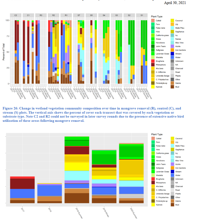
Invasive Vegetation: Mangroves 
The upper intertidal areas of the Heʻeia NERR, including the the Heʻeia Fishpond and lower reaches of Heʻeia Stream were once dominated by mangroves. Introduced to the Heʻeia wetlands in approximately 1922 to control erosion and stabilize sediment, mangrove trees spread quickly throughout the estuary. However, mangroves are an invasive species to Hawaiʻi and their introduction prevents the existence of a functioning estuarine ecosystem. While mangroves are desirable in many locations for the ecosystem benefits they provide, overgrown mangrove forests have also been shown to exclude native fishes, invertebrates, vegetation and birds with thick rhizome mats, creating anoxic conditions that limit the ability for many native aquatic species to grow (Allen, 1998; Siple and Donahue, 2013). Also, as the plant grows in the fishpond wall, its many aerial roots loosen the rocks and coral, undermining the wall's structural integrity.
The expansion of mangroves has also substantially reduced the area of marshland habitat once used by native waterbirds (Calvin Kim and Associates 1990, Brooks 1991, Helbert Hastert & Fee 2007). The USFWS recovery plan for endangered waterbirds describes Heʻeia as a site that historically had value as a complex of tidal marshes and open water areas, but which has been substantially modified and presently consists of nonnative mangroves, remnants of ponds, and wet pasture. The recovery plan recommends that Heʻeia be restored and managed by the state to provide enhanced habitat for endangered waterbirds (USFWS 2011).
Kākoʻo ʻŌiwi, through its Māhuahua ʻAi o Hoi Project, and after a required environmental review process, has initiated the removal of approximately 20 acres of the mangroves that are occluding the stream channel and to replace them with native plants such as baby tears that will serve as habitat for birds and as a nursery for juvenile fish (Townscape 2011a, 2011b).
For the Heʻeia fishpond, mangrove removal efforts began in the late 1990s with the former fishpond lessee, Mary Brooks, with help from students from UH. Paepae o Heʻeia began removing mangrove in earnest in 2001, using simple handsaws and loppers, and later chainsaws. Thousands of volunteers working tens of thousands of labor hours have been devoted to removing mangrove over the years. As of 2020, Paepae o Heʻeia had physically removed mangrove from over 5,000 feet of the 7,000-foot-long kuapā.
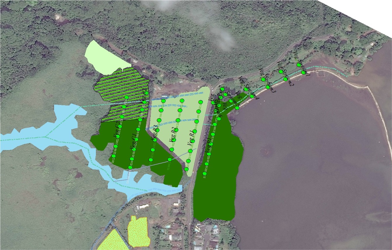
Map of vegetation survey Points. Courtesy of Kim Falinski
Native Agroforestry: Puʻulani, Kākoʻo ʻŌiwi
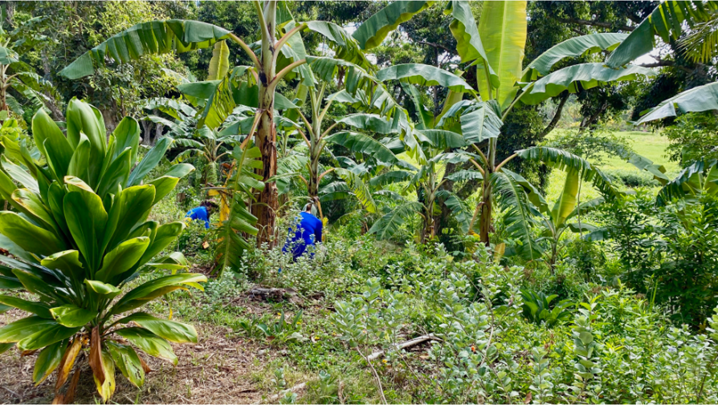
Puʻulani is the site of a collaborative agroforestry restoration project with Kākoʻo ʻŌiwi and the University of Hawaiʻi at Mānoa. Puʻulani (heavenly ridge) is located above the eastern edge of Pāhele (where Kākoʻo ʻŌiwi is restoring loʻi kalo) and is the highest point that is easily accessible to the staff and community at Kākoʻo ʻŌiwi. At Puʻulani, we are restoring the ecology of the place and people's connection to place through agroforestry, practices that integrate trees and shrubs with other tended and harvested plant and animal species. Indigenous agroforestry was widespread in Hawaiʻi for nearly a millennia prior to European colonization. Today, Kākoʻo ʻŌiwi aims to extend agroforestry systems to the slopes and uplands of their stewarded area (approximately 200 acres).
Puʻulani had been covered in Indigenous agroforest and/or native forest prior to colonization, then was used for cattle grazing, and since then non-native forest species have moved in. In fall 2018, we selectively cleared the non-native forest, predominantly Java plum, fiddle wood, and schefflera, on the eastern face of Puʻulani (0.5 acres). In a huge community effort, we planted over 2,000 culturally valuable and useful plants of 25 species. We selected plants for the first round of planting that feed people spiritually and intellectually– lei plants, plants used in lāʻau lapaʻau (traditional Hawaiian medicine), and ceremonial plants. All but three of the original plants are native; the others are non-native, non-invasive plants with important uses to the community. Here is a full list of species and their uses.
By Maile Wong, Zoe Hastings and Leah Bremer
About the Authors:
Maile Wong is an undergraduate researcher and field manager at Puʻulani with SeaGrant and the Water Resources Research Center in collaboration with Kākoʻo ʻŌiwi. She is a senior in the Botany and ʻŌlelo Hawaiʻi programs at the University of Hawaii at Mānoa.
Zoe Hastings is a postdoctoral researcher with the Water Resources Research Center and the School of Life Sciences at the University of Hawaiʻi at Mānoa who works on projects related to conservation and restoration on agricultural lands. She helped with the initial design and implementation of the restoration at Puʻulani and continues to collaborate on stewardship and research.
Leah Bremer is research faculty at the Water Resources Research Center and UHERO at the University of Hawaiʻi at Mānoa. She works on a variety of projects focused on watershed conservation and management and is PI on several grants for Puʻulani in collaboration with Kākoʻo ʻŌiwi and an interdisciplinary research team.
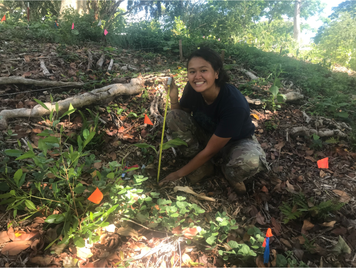
Research carried out at Puʻulani broadly aims to understand how different metrics of restoration success change over the transition from non-native forest to culturally important agroforest. We are currently tracking changes in 1) soil health; 2) the capacity of agroforests to sequester above-ground and soil; 3) growth, survival, and understory cover of the plants; 4) community members' connection to the site. Research is evolving and new projects will continue to help us understand best practices for implementing restoration through agroforestry, and the many benefits. Current UH Mānoa departments involved in this collaboration include the Water Resources Research Center, the School of Life Sciences, the University of Hawaiʻi Economic Research Organization, and the Department of Natural Resources and Environmental Management. You can find information on the participatory design, carbon storage, and ecological results to date at the embedded links. Mahalo to our funders including the Natural Resources Conservation Service, the Social Science Research Institute, the University of Hawaiʻi Sea Grant College Program, the National Science Foundation, the Heʻeia NERR, and the Kaulunani program (DOFAW).
For more information about or to come out and see or volunteer at Puʻulani, contact Leah Bremer (lbremer@hawaii.edu), Zoe Hastings (zchastin@hawaii.edu), or Maile Wong (mailekw@hawaii.edu)
IV. Invertebrates
Crabs
By Kaleonani Hurley
About the Author:
ʻO wau ʻo Kaleonani Hurley. No Mililani mai au. Noho au i ke ahupuaʻa ʻo Honouliuli, ʻo ʻEwa ka moku. I have a Bachelor of Science degree in Marine Biology from the University of Oregon. I also have a Master of Science and Doctor of Philosophy degrees in Zoology with emphasis on Marine Biology from the University of Mānoa at Hawaiʻi. I'm interested in how we can use academic tools and resources to support reciprocal and equitable relationships with communities and resources.
ʻAʻama
Scientific name: Grapsus tenuicrustatus (Herbst, 1783)
Common name: Thin-shelled crab, Natal lightfoot crab
Origin: Native to Hawaiʻi; Also Indo-West Pacific
Habitat: Marine; rocky shore, intertidal, supratidal. May be found on fishpond walls
Distinguishing features: Typically black, with long legs and short claws. Herbivorous – scrapes turf algae from rocks
Nā ʻike Hawaiʻi: Eaten raw and salted, rarely cooked. Said to have been a special or favorite sacred food for certain preists (Titcomb et al. 1978). The term ʻaʻama also means “to spread and relax, as the fingers.” This was a sacrificial crab offered so that the gods would loosen and grant the request (Pukui & Elbert 1986).
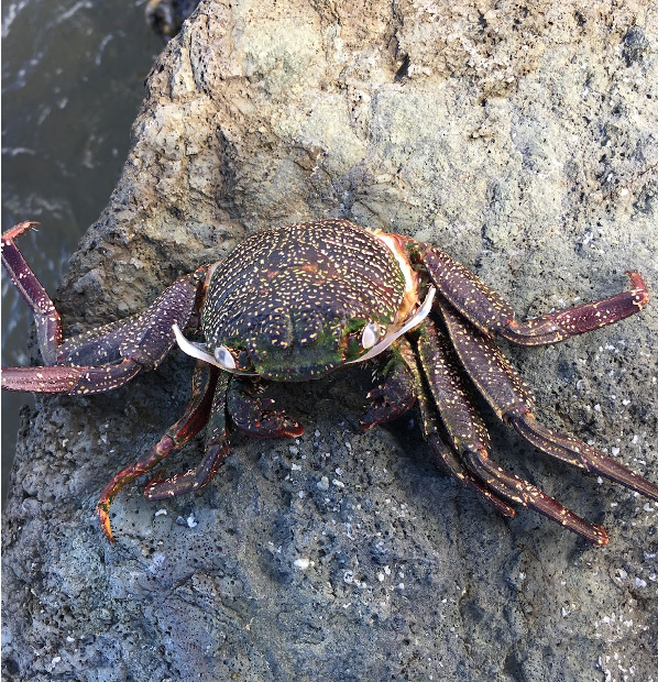
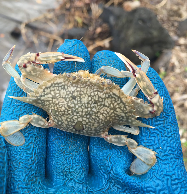
Kūhonu, kuahonu, kuohonu
Scientific name: Portunus sanguinolentus hawaiiensi
Common name: White crab, haole crab, three-spot crab, blood-spot swimming crab
Origin: Subspecies endemic to Hawaiʻi; closely related parent species found throughout Indo-West Pacific
Habitat: Marine; sandy, shallow down to 146 m (as identified in HURL images). May be found in fishponds
Distinguishing features: As a member of the Portunidae, has modified paddles for dactyls on fifth pair of legs; long anterolateral spines; mottled, sandy colored with three red spots on carapace. Carnivorous, claws effective for cutting fish
Ka ʻike Hawaiʻi: Eaten raw or cooked, roe can be used as relish. Historically common in Kanēʻohe Bay but not seen in large sizes or large population in recent decades. Known as white crab poke in some grocery stores, however the crab prepared in this form is not local but typically imported from Asia. Locally sourced kūhonu are caught offshore in deeper waters.
Moʻala
Scientific name: Podophthalmus vigil
Common name: long-eyed swimming crab, sentinel crab
Origin: Native to Hawaiʻi; also Indo-West Pacific
Habitat: Marine to estuary; mud and silty sand burrows
Distinguishing features: As a member of the Portunidae, has modified paddles for dactyls on fifth pair of legs; long claw arms and long eyes; reddish-brown colored
Ka ʻike Hawaiʻi: Eaten raw or cooked; up to 1946, held considerable economic importance. Sold in great numbers at fish markets of Honolulu. Lasts longer as a travel food than kuahonu and could be taken back to the mountains to be eaten (Titcomb et al. 1978).
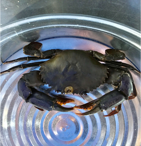
Mud Crab, Samoan Crab
Scientific name: Scylla serrata
Common name: Mud crab, Samoan crab, mangrove crab
Origin: Introduced to Hawaiʻi; Also Indo-Pacific, Red Sea, Gulf of Mexico (introduced)
Habitat: Marine, estuary; typically muddy environments, capable of walking across land for short distances to find other pools to inhabit; may be found in fishponds
Distinguishing features: Carnivorous; typically brownish black in muddy areas but may be purple toned in deeper waters; large niho (or knobs) in the claws indicate the ability to crush other hard bodied organisms;
Local Knowledge: No recognized Hawaiian name as this species was introduced in the 1920s to start a crab fishery. Local newspaper articles show a change in opinion from welcoming in the 1920s to disparaging in the 1930s, with one article stating the “Samoan crabs are infesting fish ponds, killing fish and even destroying walls by tunneling under them” (Honolulu Star Bulletin, 1936). Locally called Samoan crab because they were originally brought in from Samoa, however this species is not native to Samoa. Currently the largest crab species in Hawaiʻi, anecdotaly noted to predate on local natives (such as kūhonu). Although inhabitants of estuaries, a few individuals were noted in 2004 as bycatch in lobster traps off Nalukākala (Maro Island) and Mokumanamana (Necker Island) in Papahānaumokuākea (Moffitt et al. 2006). Tagging data from a recently published study shows they can travel 5 miles along the coastline in 3 weeks (Hurley et al. 2020).
V. Vertebrates: Fish, Reptiles and Amphibians, Birds, Mammals
Fishes
Kāneʻohe Bay supports a diversity of fish species. While there is no comprehensive list of fish species in the bay, one study focusing only on small reef fish found 202 species from 49 families (Greenfield et al. 2003). This number is corroborated by a Smithsonian Institution review of various holdings of the Smithsonian’s National Museum of Natural History, the Bishop Museum, and the Hawai‘i Institute of Marine Biology, revealing some 200+ species in Kāne‘ohe Bay. While there are a number of culturally important fish in the marine environment within Heʻeia, the fish species of utmost interest to the resource managers is the ʻamaʻama, or the Hawaiian striped mullet, Mugil cephalus. They are the prized fish traditionally cultivated in Hawaiian Fishponds; however, in the past century as land use changes and biological invasions have dramatically altered many loko iʻa, or fishponds and surrounding environments.
To restore loko iʻa and biocultural landscapes for the future, a clear understanding of how to increase and maintain productivity of key loko iʻa resource species is crucial. Target species for loko iʻa mariculture include the culturally prized native striped mullet, Mugil cephalus (called ʻamaʻama when 15-30 cm; and ʻanae when >30 cm), whose juveniles (called puaʻama and kahāhā when < 15 cm; Fig. 1) primarily consume microphytoplankton and detritus (Hiatt et al., 1947). Since its accidental introduction in the 1950s, the non-native, invasive Osteomugil engeli (Australian or kanda mullet) have become well established in the Hawaiian islands and remain a dominant species in estuaries in Hawaiʻi (Schemmel et al., 2019). Whereas ʻanae, the large, mature adults of the native species, reach a maximum length of 1 m in ~3-5 years and are seasonally reproductive, the non-native O. engeli pose a significant issue for loko iʻa, as these fish are smaller, reach maturity faster, and reproduce continuously throughout the year. Further understanding of linkages between freshwater discharges into coastal environments such as loko iʻa and native mullet feeding preferences will provide key insight for evaluating management decisions for kiaʻi loko iʻa. Study is currently underway to examine the diet and habitat preferences of ʻamaʻama and kanda mullet at Heʻeia Fishpond.
Other fish that are important indicators of the health of the ahupuaʻa are the native ʻoʻopu, or gobies, that live in Hawaiian streams. Several species travel down to the nearshore ocean waters to spawn, and the juvenile find their way back up to the stream. Other estuarine fish, such as ʻawa (milkfish), moi (threadfin), and ʻaholehole (Hawaiian flagtail) are also important indicators of connectivity in waterways through the ahupuaʻa. Main threats to native stream and estuarine fish diversity are non-native aquarium fish that have been discarded and have since dominated the stream fauna. Current research in Heʻeia NERR aims to determine the biodiversity and abundances of native and non-native fish, and examine their spatial distribution along Heʻeia Stream. These surveys include semi-annual visual, and catch and release castnet surveys, and quarterly environmental DNA surveys.
Preliminary environmental DNA data has shown that ʻoʻopu species in the Heʻeia ahupuaʻa are distinctly distributed geographically: ʻoʻopu akupa are found in the lower regions of the wetland and estuary, ʻoʻopu naniha cover the upper wetland and estuary, and ʻoʻopu nākea are found closer to the headwaters of Haʻikū Stream, and all the way down in the wetland.
BIRDS
WETLAND BIRDS
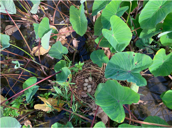
Research in the NERR on native and endemic bird species aims to understand how Hawaiian perspectives and practices of resource management and restoration support native species richness and abundance, including endangered species recovery.
By Eryn Opie
About the Author:
Eryn Opie was born and grew up in Kailua, Oʻahu. Her research interests have been in ecological restoration and conservation with a focus on native bird habitat. She completed her Master of Science degree in Department of Natural Resources and Environmental Management at the University of Hawaiʻi at Manoa. Upon completing her grad school, she shifted her focusin this field to teaching high school Conservation and Environmental Science. Her time working at Kakoaʻo ʻOiwi and the NERR inspired her to pursue teaching becuase she thoroughly enjoyed her time learning from a diversity of people with different worldviews and academic backgrounds. "Everyone taught me something and I want to pass on that notion that everyone and everything has something to teach us."
Over 6,000 ha of protected waterbird habitat is managed by state and federal entities across the Hawaiian Islands. However, sea level rise threatens many of these protected habitats, particularly lowland wetlands. Harmon et al. (2021) found that ~29% of potential waterbird habitat that exists across the Hawaiian Islands is projected to be lost to sea level rise by the end of the century. However, restoring loʻi kalo across the state has the potential to more than compensate for these losses. This research project demonstrates the potential for loʻi kalo/wai to expand conservation of Hawaiian waterbirds beyond state and federal protected areas.
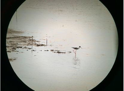
MIGRATORY SHOREBIRDS
Foraging habitat for migratory shorebirds
Shorebird population monitoring typically occurs in their breeding grounds. However, shorebird populations experience population declines across their entire range because of climate change and foraging/nesting habitat loss. This research aims to optimize monitoring strategies in the nonbreeding grounds that capture shorebird resource use, detectability, and their biological response to restoration within the NERR.
By Claire Atkins
About the Author:
Claire started working in Heʻeia as a NERR intern in early 2021 examining the impact of monitoring design on shorebird occupancy data. She has since joined the water quality team as a technician and will continue her work with Heʻeia's migratory shorebirds as a graduate student.
Kōlea are ʻaumakua, with striking breeding plumage that has been used in feather work. They were once a valuable meat source as well as navigational aides and harbingers of seasonal change. Kōlea, ʻŪlili, and ʻAkekeke have onomatopoeic names, which mimic the sound of their vocalizations1 , and each is considered to be either a messenger or scout for the gods. In archival Indigenous taxonomic records, all three are described as both nā manu o ka ʻāina (birds of the land) and nā manu ʻelepaio / nā manu lawaiʻa / nā manu o ke kai (ʻElepaio birds / fishing birds / birds of the sea)2 because of their dual-system resource use.
"A brief explanation must be given for the name of the category nā manu ʻano ʻelepaio. The ʻelepaio are a group of endemic old-world flycatchers whose diet mainly consists of various forest invertebrates. The reason why a category entirely composed of seabirds and shorebirds would be named after a small forest bird is because in kanaka maoli tradition, one of the more common calls of the ʻelepaio sounds like the phrase, ʻono ka iʻa! (fish is delicious!), which implies that the ʻelepaio is asking the listener to give the bird some fish to eat. To the listener, it is as if the ʻelepaio, a bird of inland forests, is too lazy to go down to the sea and get some fish for itself. Instead it asks the listener to do it for them. The name of this category references that all birds listed within it eat aquatic organisms." -(Gomes, 2020)
MAMMALS
Puaʻa Pigs
Pua‘a were brought to the Hawaiian Islands with the first Polynesian voyagers and genetic evidence indicates these pua‘a to were descended from the Asiatic wild pig or Sus scrofa subsp. Vittatus (Maly et al., 2018). Oral traditions indicate that pua‘a were domesticated and largely confined to kauhale (family compound) in pā pua‘a (pig pens) so that critical staples like taro and sweet potato were protected (Maly et al., 2018). While small populations of puaʻa could and may have been free-roaming pre-contact, without introduced flora such as guava and fauna such as earthworms, these populations would have been dependent on people to survive and thrive.
By A. Nalani Olguin
About the Author:
A.Nalani Olguin is currently enrolled in the Marine Biology Program in Dr. Rosie Alegado's Laboratory at the University of Hawaiʻi at Mānoa. She is a graduate assistant with Heʻeia NERR who has been working collaboratively with the reserve, site-partners and community members in Heʻeia to assess feral introduce species impacts on nearshore communities.
The Kumulipo, one of the documented creation chants, gives an account of the creation of Kamapuaʻa (the deity “the pig child”). According to that same tradition, Hawaii is the only place in Polynesia where a pig was worshiped (Kirtley 1971:115-117). Hawaiian language and oral tradition is littered with references to pua‘a from important terms related to land divisions such as “ahupua‘a” to moʻolelo about mischievous Kamapua’a. The pig god was closely associated with Lono, god of agriculture.
New breeds of pigs were introduced to Hawaiʻi after Western contact. The “feral” pigs of Hawaiʻi today are descendants of the introduced European, Asian, Russian and Polynesian pigs of old. With Hawaii devoid of predators other than human, and the introduction of guava, mango, earthworms and other root plants, the feral pigs were able to thrive and establish a large population throughout the Hawaiian Island chain. Although today Sus scrofa play a destructive ecological role and they are not the same polynesian pua‘a initially introduced, they maintain a cultural significance and a body of cultural knowledge exists around hunting and game management.
The Heʻeia watershed has an abundant population of feral pigs whose exact population remains unquantified, and concerns about impacts on crops and water quality have been voiced by land stewards in Heʻeia. In a current research project, methodologies including camera traps are used to determine abundances of feral pigs in the upper ahupuaʻa regions. This will assess the abundance of pig-associated bacterium in the waterways to develop a topographic model of potentially loaded zones. This work will also aid in the Heʻeia ahupua’a restoration and help guide development of monitoring tools to foster self-sufficient communities developed management practices.
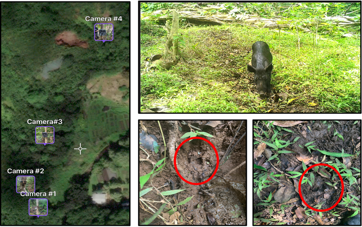
Cats (Felis catus)
Felis catus (cats) were introduced to Hawaiʻi over 200 years ago and with no other predatory mammals of comparable size cats thrived, rapidly becoming abundant (Hess et al., 2004). Currently there is no accurate population count across the Hawaiian Islands. While there is no definitive data, it is estimated there are about 300,000 feral cats on O‘ahu alone.
By A. Nalani Olguin
Cat colonies are human dependent and supported through “feedings” in designated locations set up through non-profit organizations/community groups. He‘eia State Park is known for its large feral cat population. A 2019 study at He‘eia suggests that the population at the park is about 99 cats on average (Lepczyk et al., 2020).
Feral cats are a host of the harmful parasite Toxoplasma gondii, which can infect humans and marine mammals such as monk seals and whales. Researchers are conducting studies on the feral cat population and pathways of dispersal of T. gondii oocytes into waterways to identify risks and management strategies.
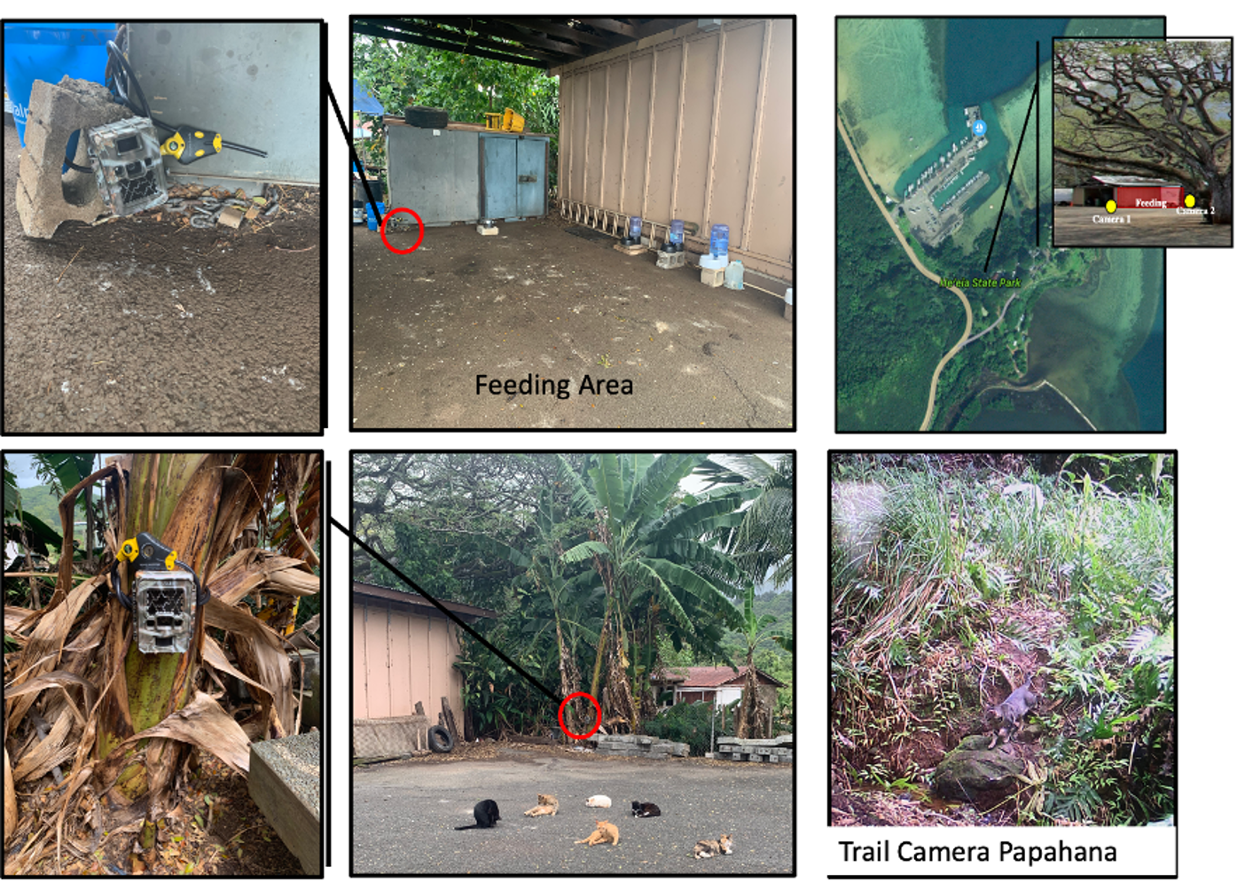

Partnering Organizations
Acknowledgements
The Heʻeia National Estuarine Research Reserve is part of the National Estuarine Research Reserve System (NERRS), established by section 315 of the Coastal Zone Management Act, as amended. Additional information about the system can be obtained from the National Estuarine Reserve Division, Office for Coastal Management, National Oceanic and Atmospheric Administration, U.S. Department of Commerce, 1305 East West Highway - N/ORM5, Silver Spring, MD, 20910.
Back to Top